
Culture & History
By Chérie Haury-Artz
Humans have been interacting with the landscape in Northwest Iowa for over 13,000 years. The state holds more than 32,000 recorded archaeological sites, ranging from ancient Native American camps, villages, and trade centers to historic farms and forts.
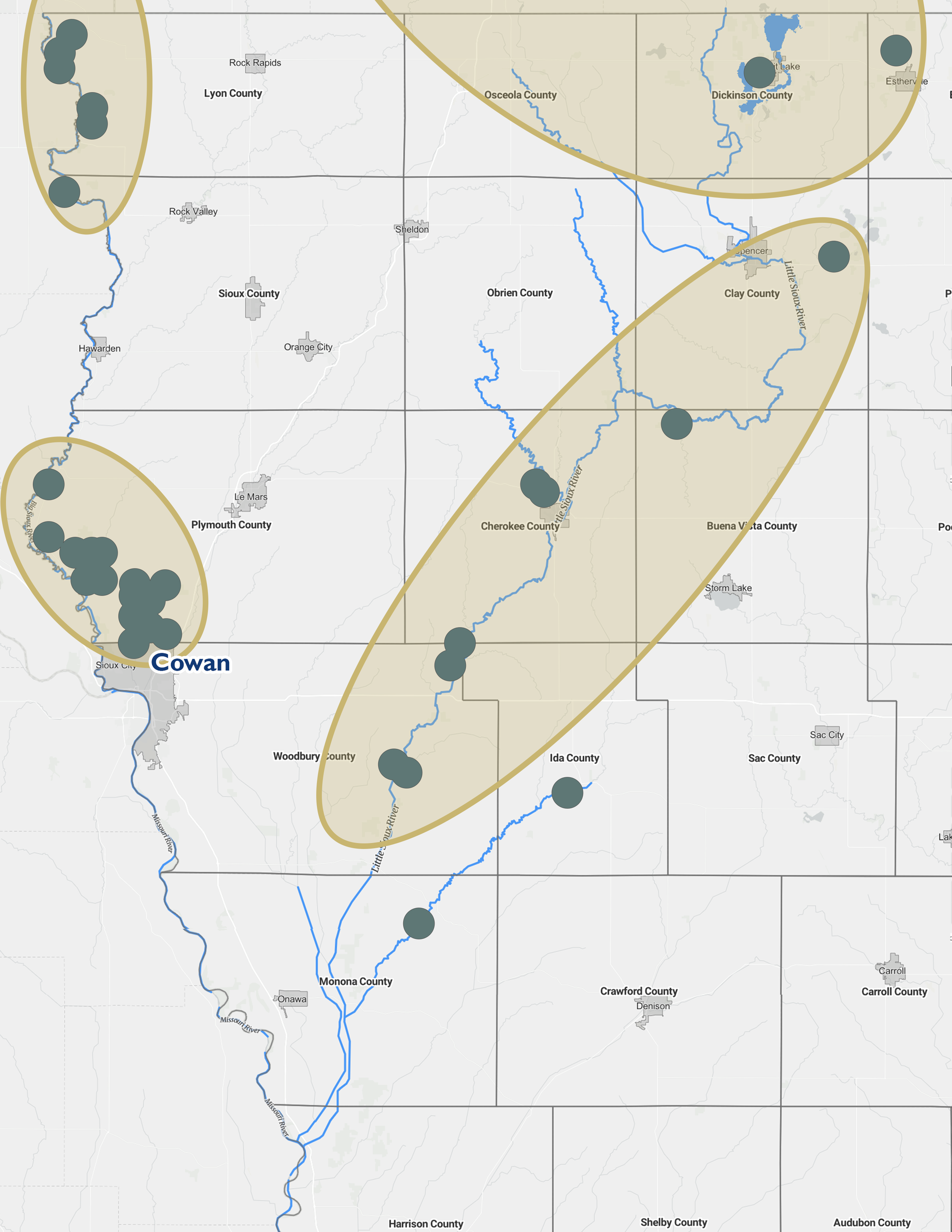
The Little Sioux River region has long supported human life with its rich plant and animal resources, fertile floodplains, and accessible waterways for travel and trade. Archaeologists have conducted over 150 investigations, identifying nearly 250 sites, with 40% located near the river. The region also includes three National Register historic districts.
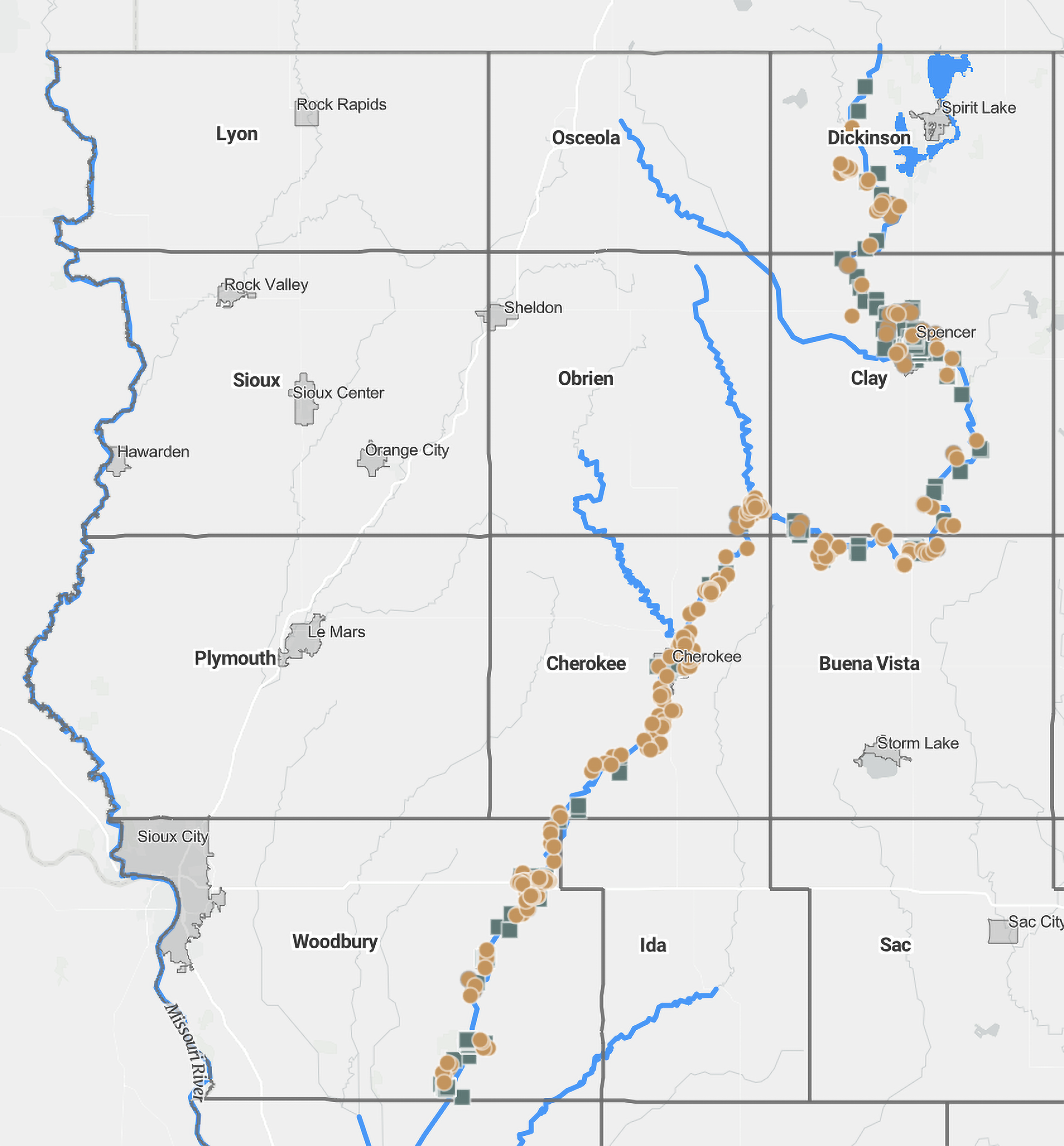
Identified archaeological points of interest along the Little Sioux River
(Map: University of Iowa Office of the State Archaeologist)
To protect these cultural resources, artifact collecting is illegal on public lands (including riverbeds and banks of meandered streams) and requires landowner permission on private property.
Iowa’s archaeological record is divided into time periods based on shifts in technology, subsistence, and settlement patterns, determined through methods like radiocarbon dating and stratigraphy. These periods outline the deep and continuous Native American history that forms an essential part of Iowa’s and America’s heritage.
Paleoindian Period ~ (11,500-8,500 BCE)
The Paleoindian Period marks the earliest known human presence in the Little Sioux River region, beginning around the end of the Pleistocene Ice Age over 13,000 years ago. As glaciers retreated, the area featured cool forests and grasslands inhabited by Ice Age megafauna like mammoths and giant bison.
Ancestors of Native Americans living during this period were highly mobile hunter-gatherers, living in small groups that moved seasonally to hunt and gather wild plants. Their most distinctive artifacts are fluted stone projectile points (such as Clovis and Folsom types), designed for efficient hafting and durability [1]. These tools reveal advanced flint-knapping techniques and cooperative hunting strategies.
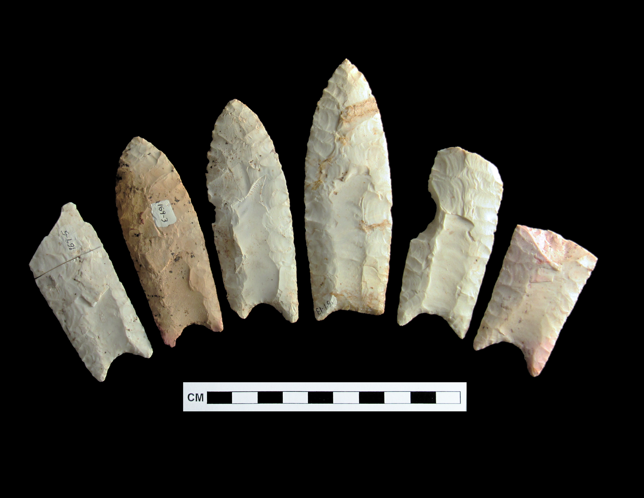
Clovis Points
(Image: University of Iowa Office of the State Archaeologist)
Few intact Paleoindian Period sites remain in Iowa due to erosion and burial, but isolated finds—like a Clovis point from Woodbury County—confirm their presence across the state. Over time, unfluted lanceolate points replaced earlier fluted ones, showing increasing regional adaptation as the climate warmed [2]. One significant local example is the Cherokee Sewer site, which preserves evidence from the late Paleoindian period [3][4][5].
Archaic Period ~ (8,500 – 800 BCE)
Following the retreat of the glaciers, Iowa’s climate warmed and dried, leading to the extinction or adaptation of Ice Age megafauna. Around 6,000–8,000 years ago, during the Hypsithermal, Iowa experienced its warmest, driest period before gradually cooling to modern conditions.
Human cultures adapted to the changing climate and archaeologists call the cultural developments that reflect these changes the Archaic period. Archaeological evidence indicates increasingly diversified hunting and gathering economies and regional developments. People hunted bison, elk, deer, and smaller animals, and gathered a wide range of plants and nuts.
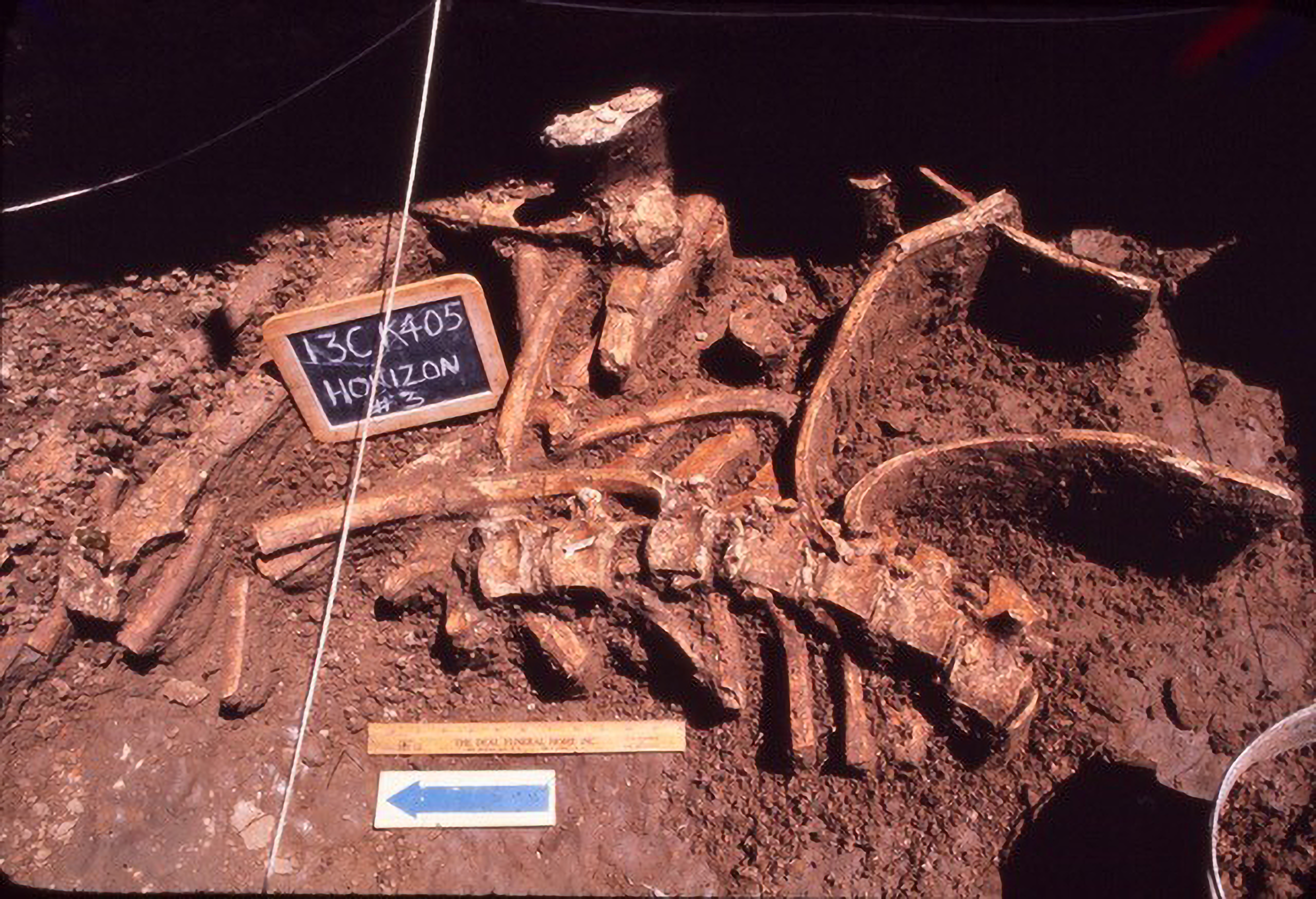
Remains of Bison bone found at the Cherokee Sewer Site (13CK405)
(Image: University of Iowa Office of the State Archaeologist)
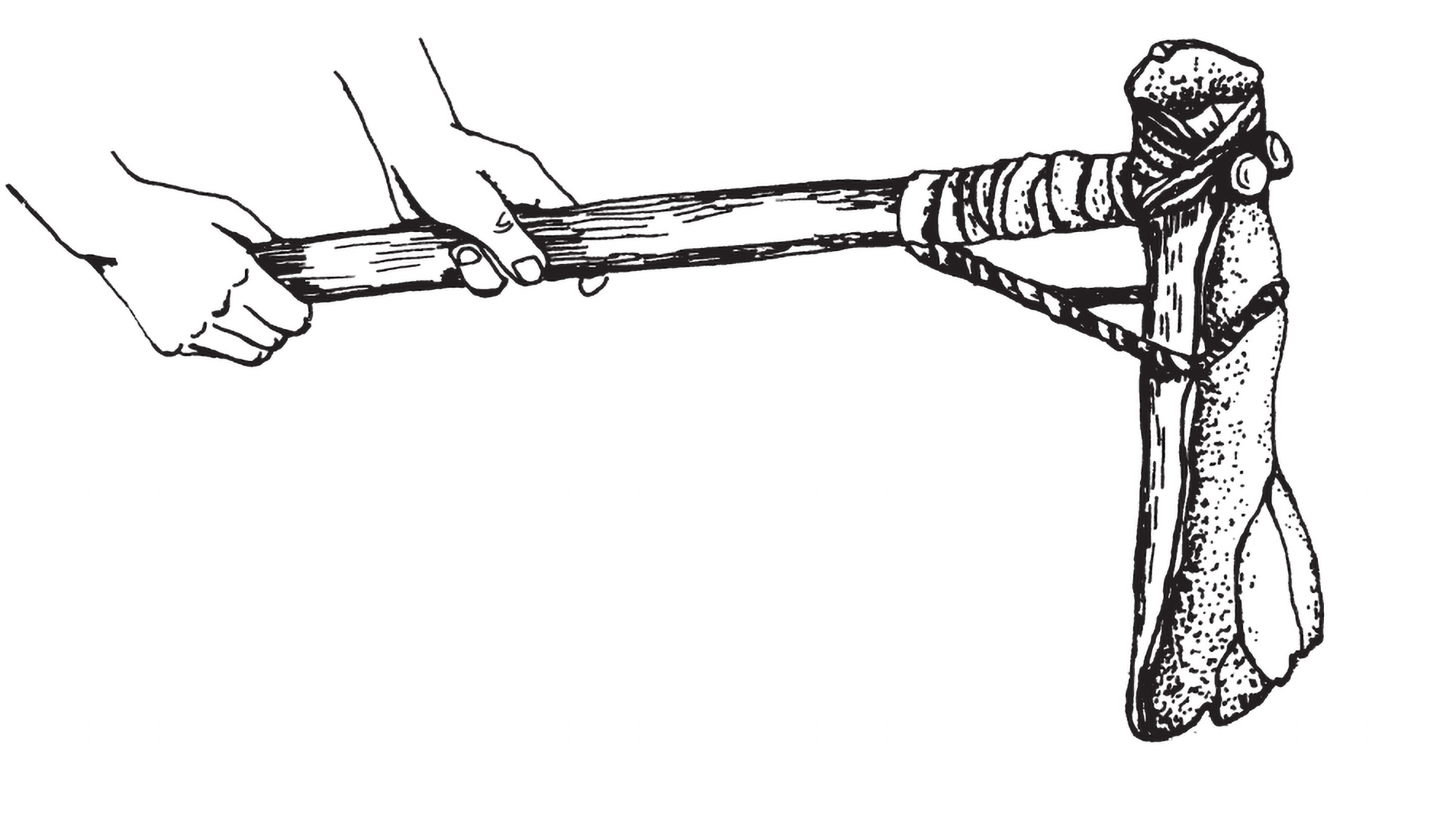
Technological changes included notched and stemmed projectile points, often used with the atlatl for more powerful throws [6]. Other tools—such as scrapers, drills, axes, grinding stones, and bone ornaments—reflect a broadening toolkit and resource use.
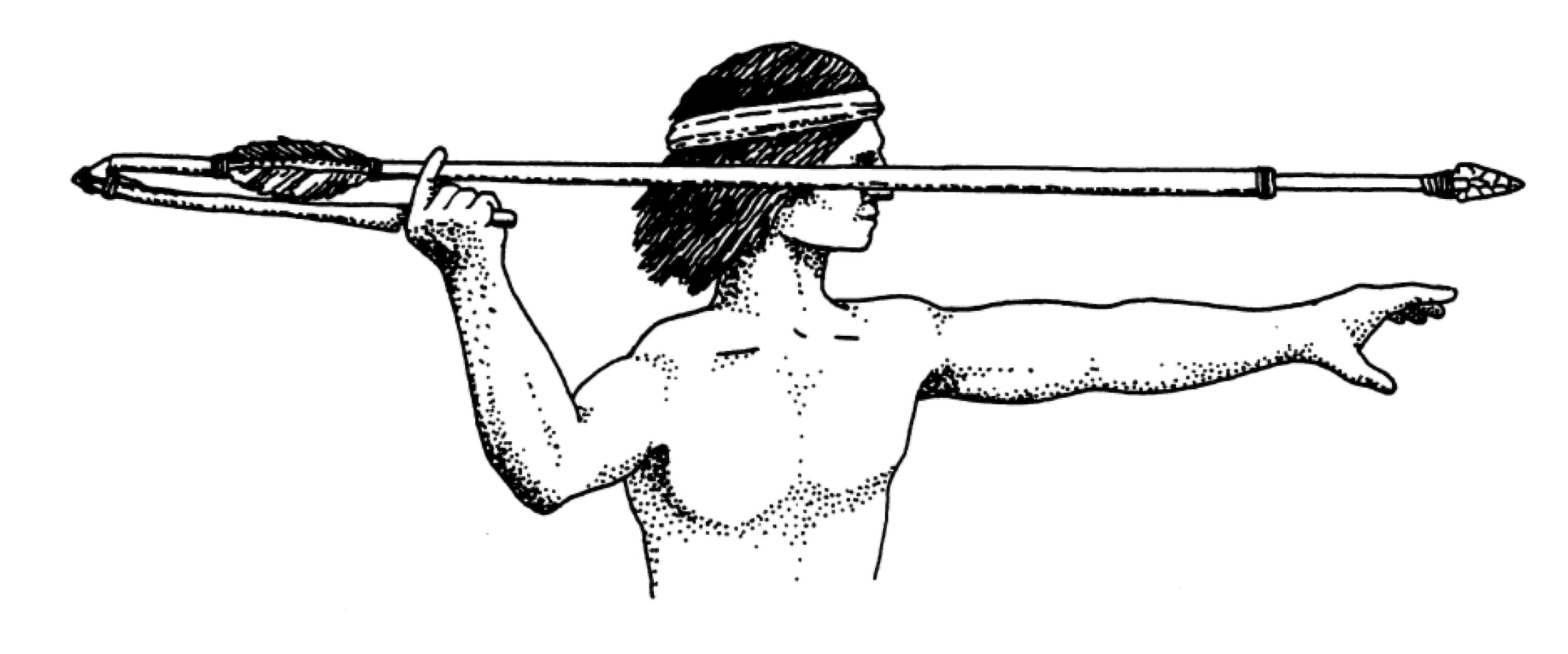
An illustration of an individual preparing to use an Atalatl
(Image: University of Iowa Office of the State Archaeologist)
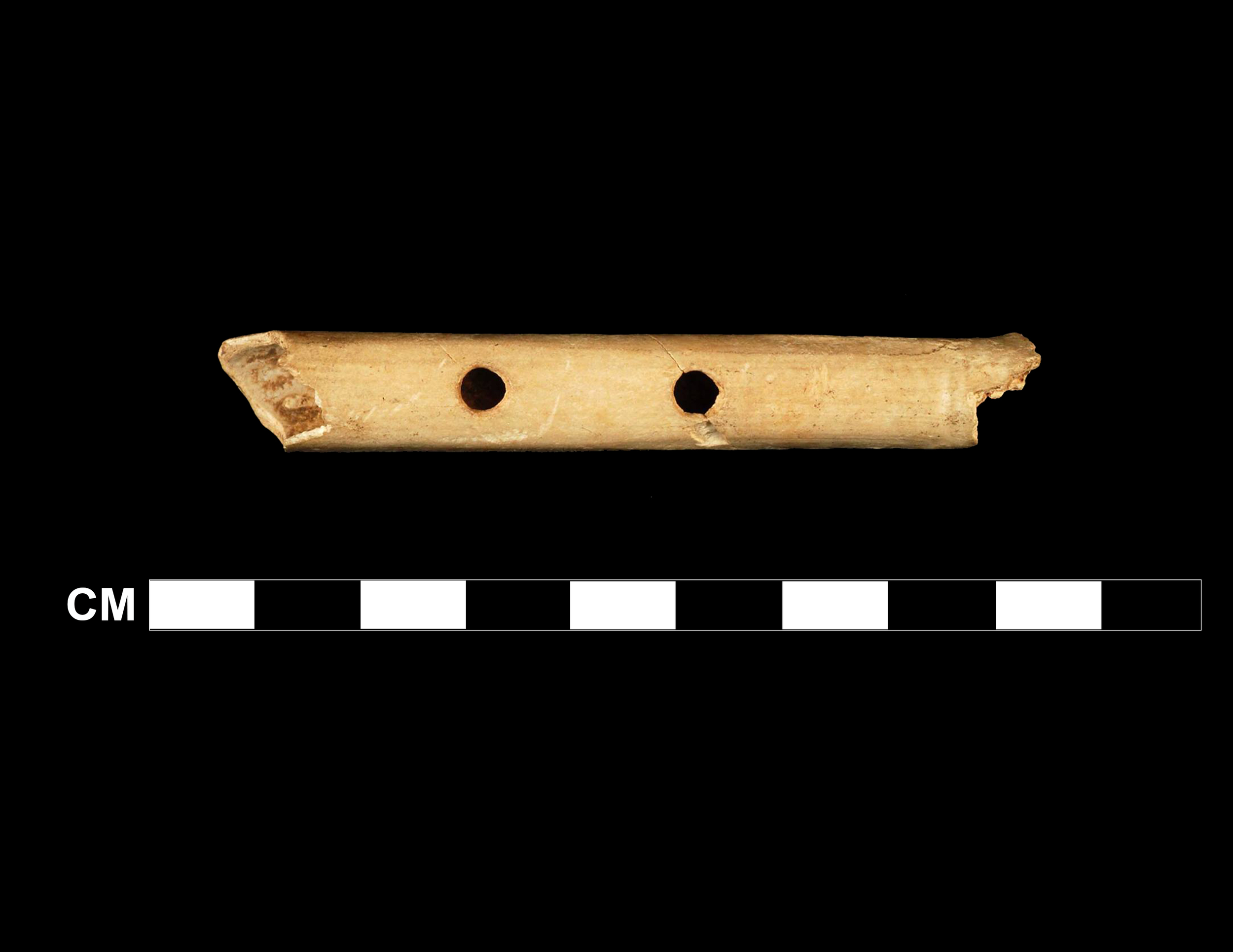
A flute made from the wing bone of a swan, found at the Cherokee Sewer Site (13CK405). Believed to be the oldest musical instrument found in the United States.
(Image: University of Iowa Office of the State Archaeologist)
The period is divided into three phases:
Early Archaic (8500–5500 BCE): Transition from Ice Age; small, mobile groups.
Middle Archaic (5500–3000 BCE): Warm, dry climate; settlements concentrated along rivers.
Late Archaic (3000–800 BCE): Population growth, trade networks, and regional adaptation to diverse environments.
The Archaic Period ended with new technological and cultural innovations—including influences from expanding trade and shifting climates—that set the stage for the Woodland Period.
Woodland Period ~ (800 BCE – CE 1000)
During the Woodland Period, Iowa’s climate stabilized into the familiar forest–prairie mix seen by early settlers. Cultural innovations—rather than environmental changes—defined this era, marking a shift toward more complex, settled lifeways.
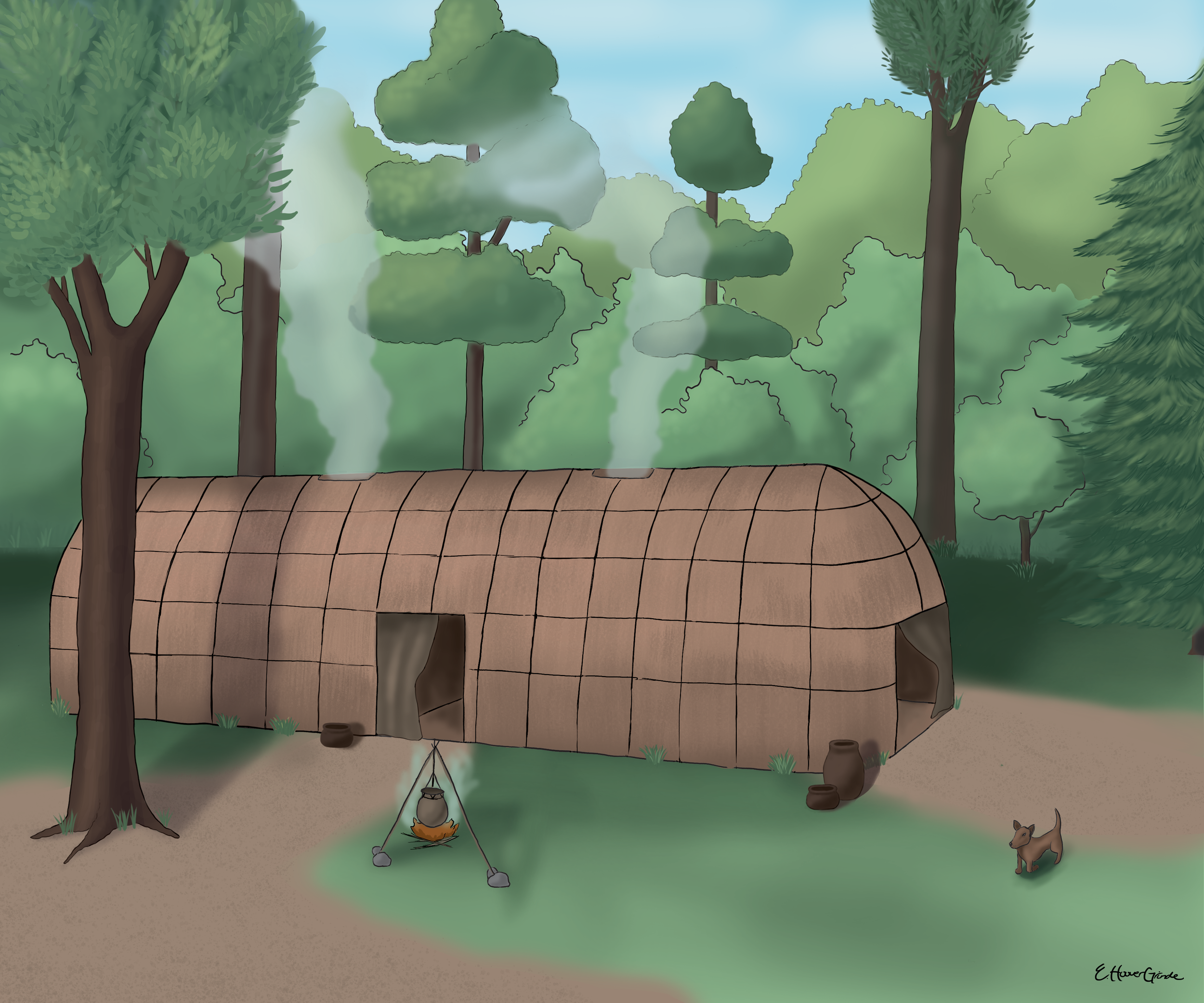
An illustration of a permanent structure like the one excavated at the Rainbow site in Plymouth County.
(Illustration: Emma Hoover-Grinde)
Key developments included the introduction of horticulture and plant domestication, pottery making, the bow and arrow, and the construction of burial mounds. Populations expanded and settlements became more widespread, often seasonally reoccupied by family groups who hunted bison and gathered wild foods [7].
Archaeological evidence, such as the Rainbow site in Plymouth County, shows semi-permanent homes made of posts and bark or reed coverings [8]. People cultivated native plants like goosefoot, sunflower, knotweed, and amaranth, supplementing them with wild foods such as walnuts and plums [9]. Bison bone hoes were used for farming and grinding stones for grain processing, while pottery emerged for storing and cooking dried produce [10].
An illustration of a hoe made from the scapula (shoulder blade) of bison.
(Illustration: University of Iowa Office of the State Archaeologist)
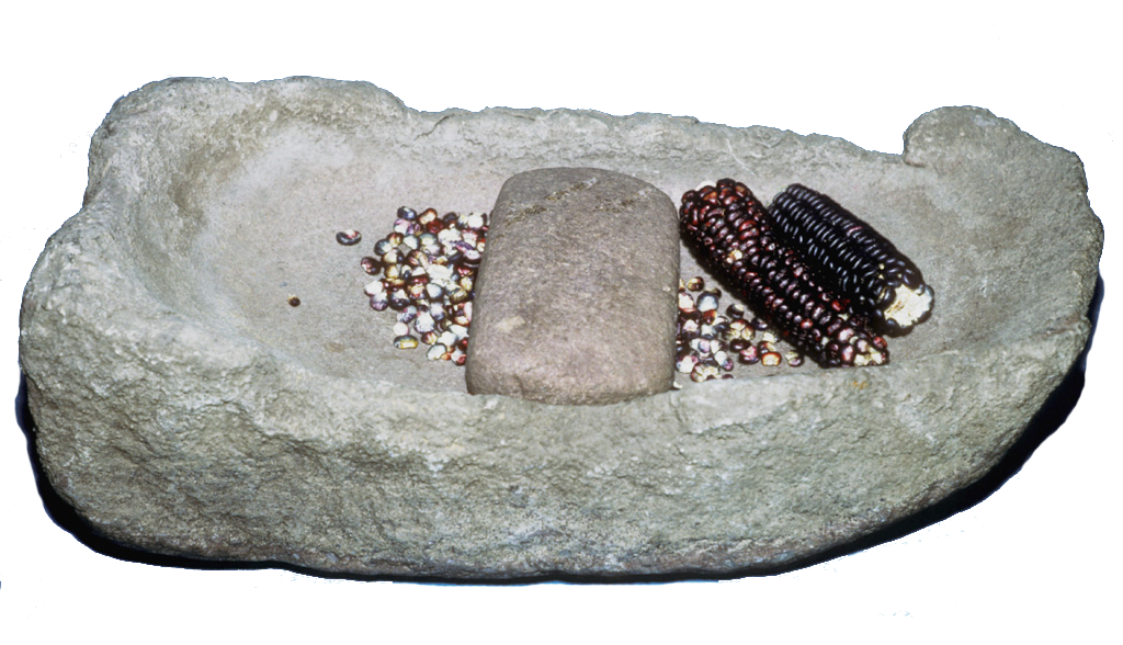
A grinding stone like this were used heavily to process grain during the woodland period.
(Image: University of Iowa Office of the State Archaeologist)
The Middle Woodland period (200 BCE–CE 300) saw widespread trade networks, exchanging materials such as copper, shell, mica, and pipestone, and a flourishing mound-building tradition for burials and ceremonies [11].
By the Late Woodland period (CE 300–1000), populations grew further, bow-and-arrow hunting replaced atlatls, and maize (corn) was introduced from the southwest. People increasingly combined localized hunting, gathering, and small-scale gardening, setting the stage for more agricultural societies to come.
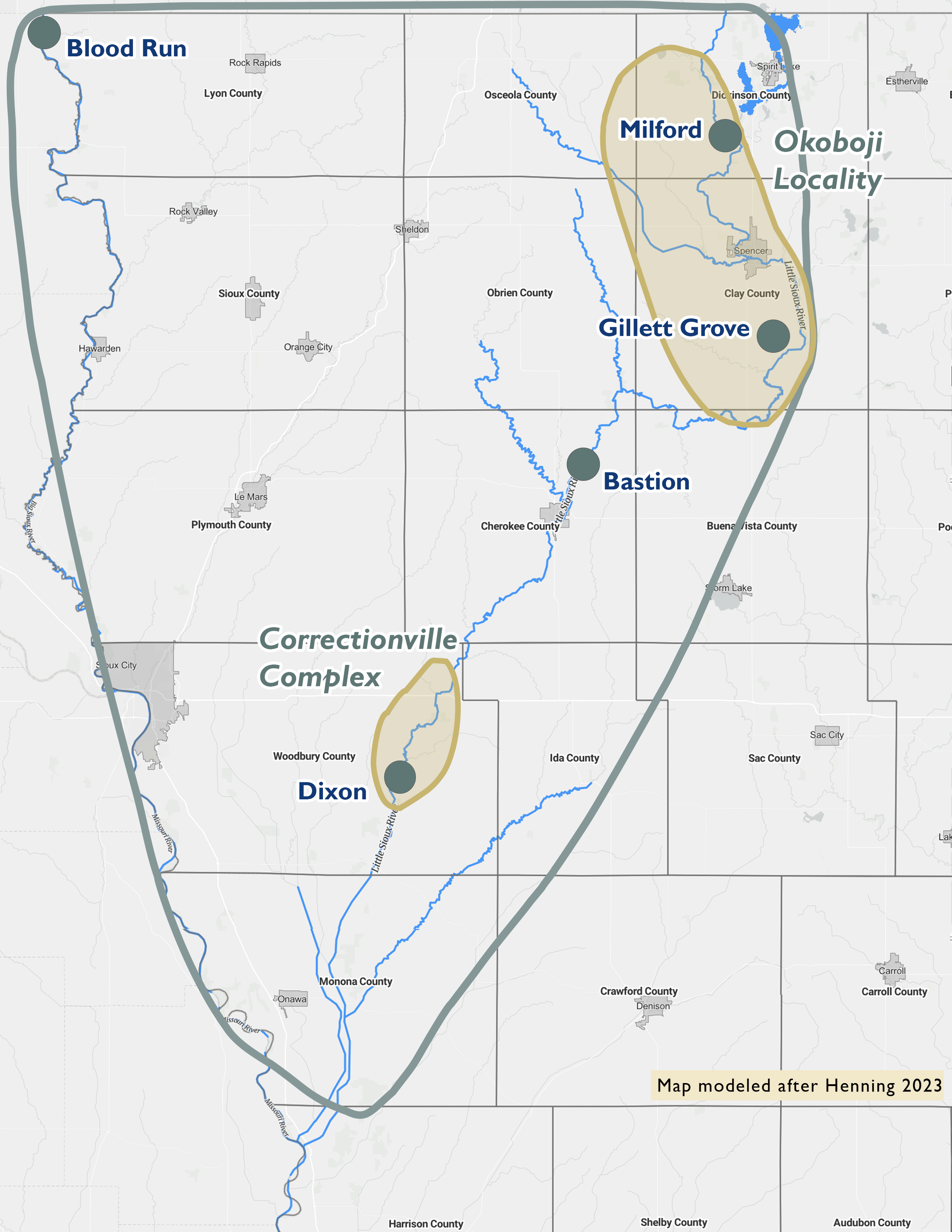
Great Oasis Culture (~CE 900 - 1100)
A map of Great Oasis sites in Northwest Iowa.
(Map: University of Iowa Office of the State Archaeologist)
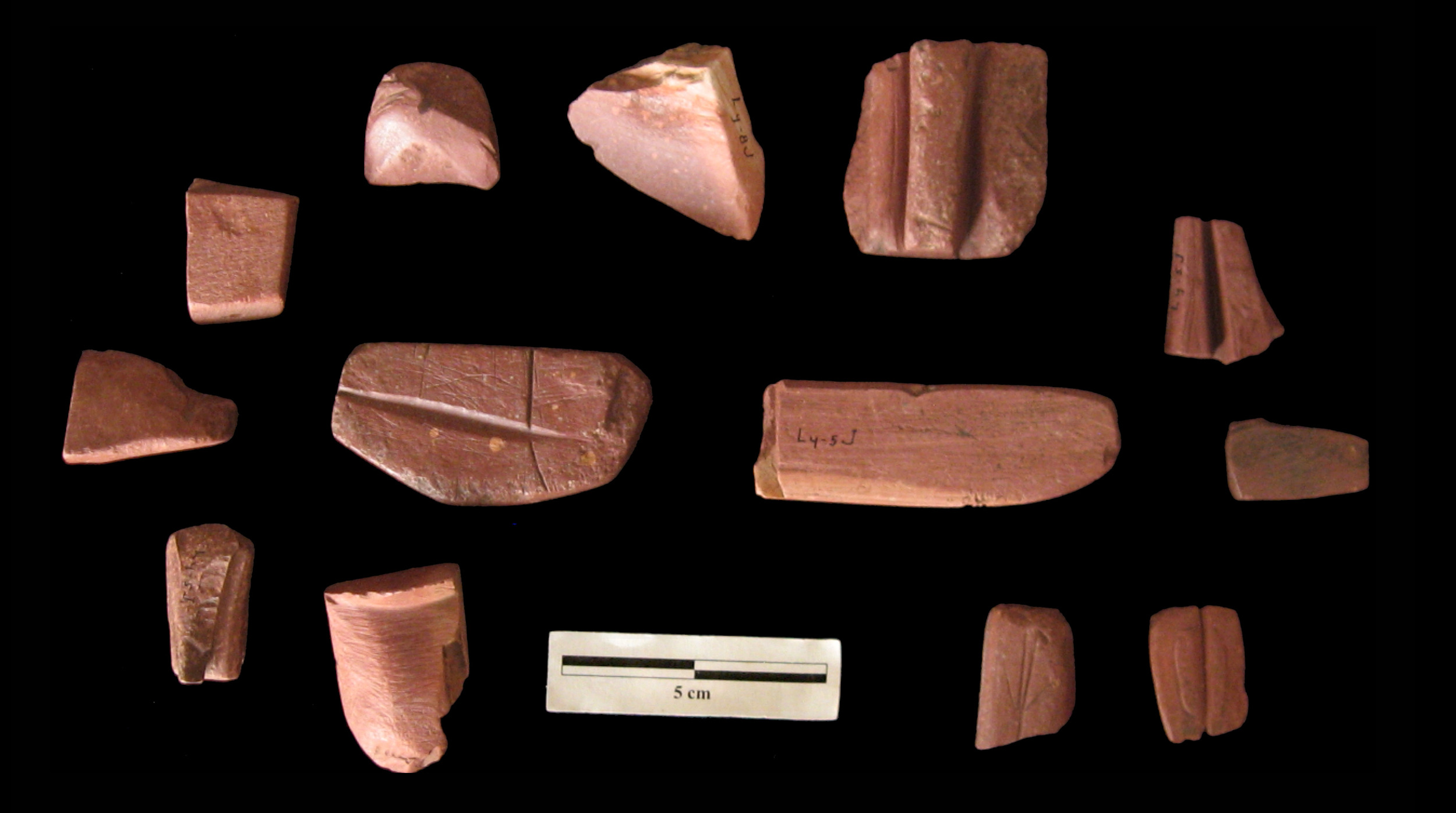
Archaeologists coined the term “Great Oasis” to define a distinctive archaeological culture that emerged at the very end of the Woodland period (~CE 900), marking the rise of semi-permanent villages and advanced corn farming. Their food economy combined bison hunting with cultivation of corn, squash, gourds, sunflowers, chenopod, and little barley [12]. Key sites include the Crocker Site (Cherokee County) and Cowan Site (Woodbury County), notable for large storage pits indicating successful food production [13]. Great Oasis ceramics are distinctive: globular pots with rounded bases, high rims, grit-tempered clay, incised geometric designs on rims, and the smoothed-over cord-marked bodies were usually undecorated.
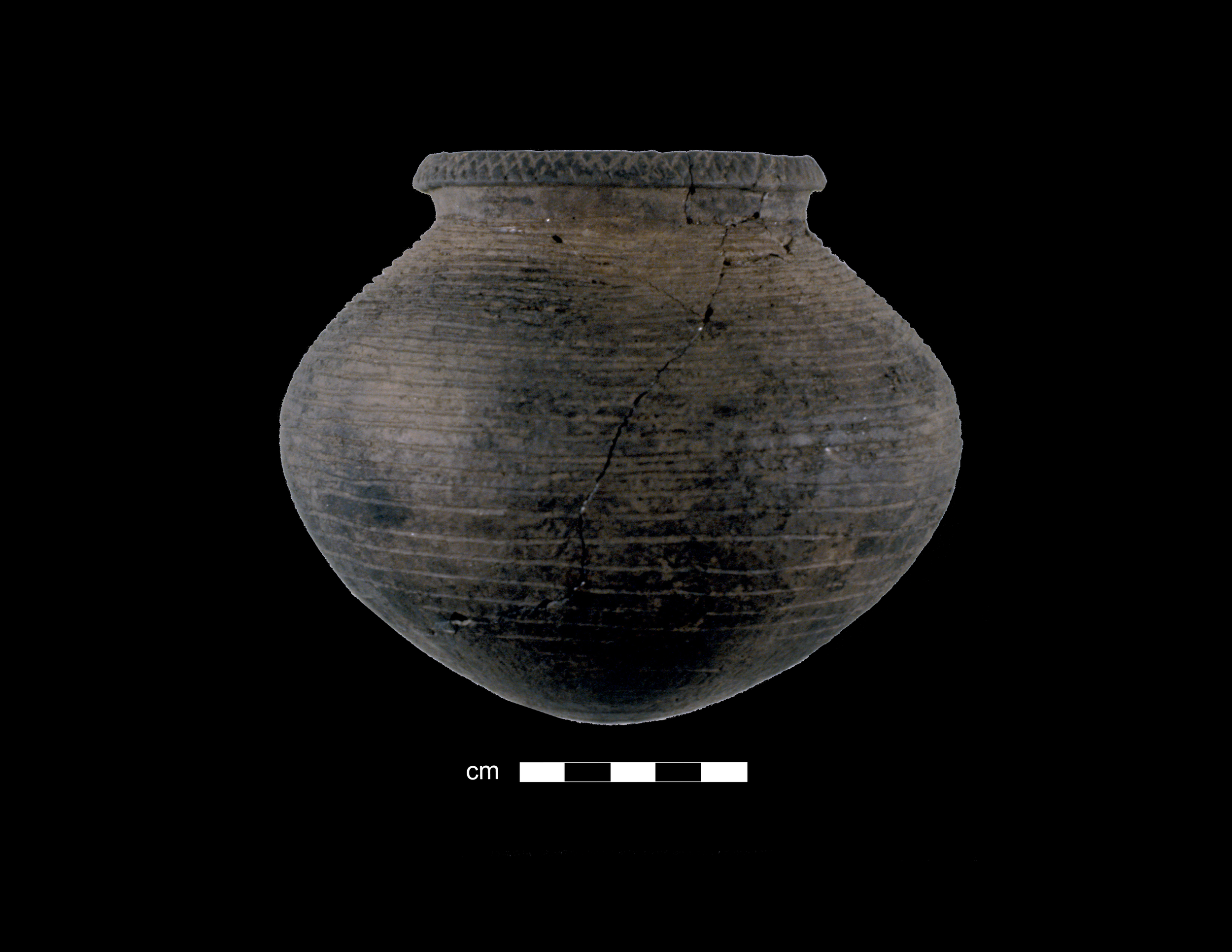
Great Oasis ceramics are distinctive globular-shaped (round) pots with rounded bases, high rims, and grit (sand or crushed rock) mixed into the clay for tempering.
(Image: University of Iowa Office of the State Archaeologist)
Late Pre-Contact Period ~ (CE 1000-1700)
With the introduction of corn and beans, farming in northwest Iowa thrived. This gave rise to large, permanent villages along the Little Sioux River. Two major cultural traditions emerged — Mill Creek and Oneota — both blending farming, bison hunting, and trade within the tallgrass–shortgrass Plains region.
Mill Creek Culture (CE 1100–1250)
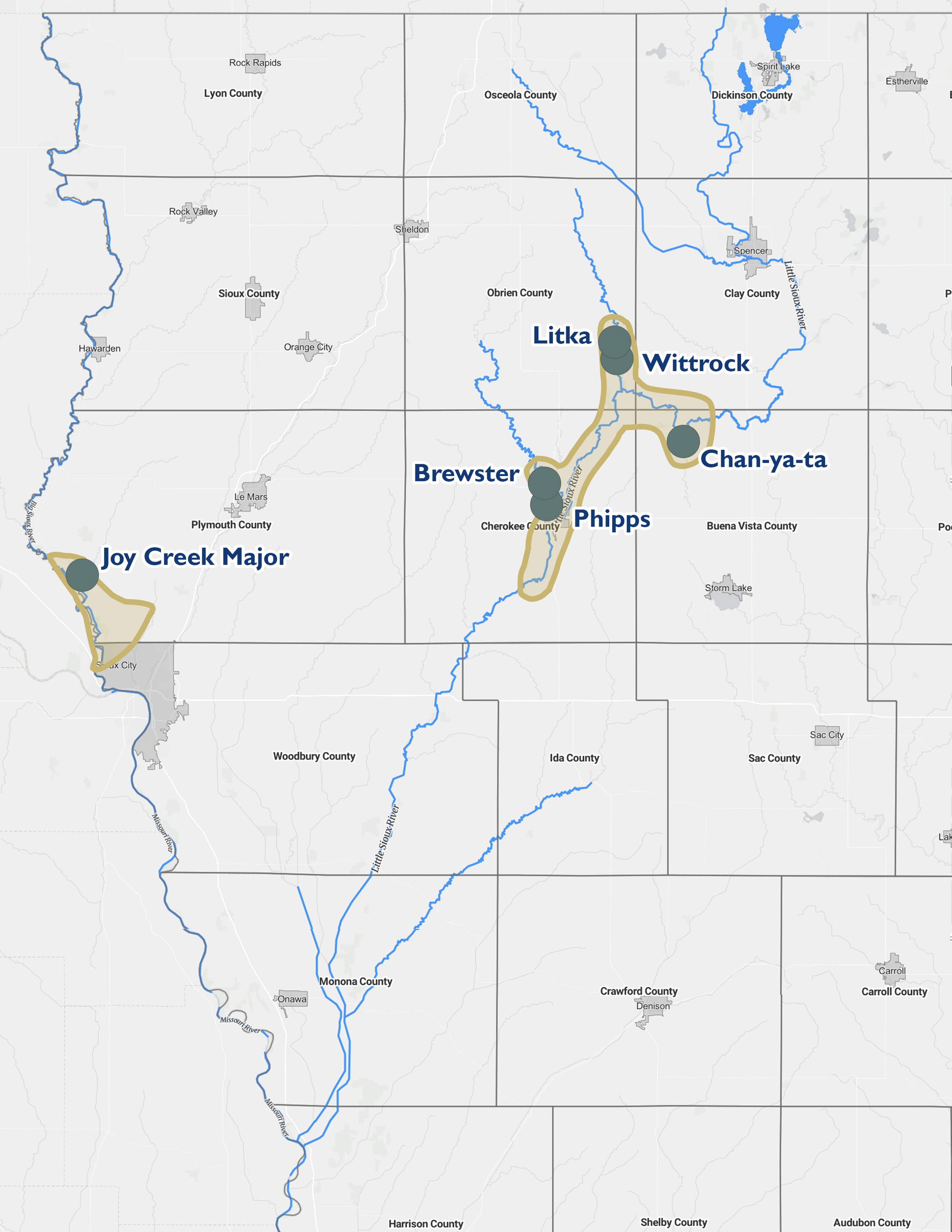
A map of Mill Creek sites in Northwest Iowa.
(Map: University of Iowa Office of the State Archaeologist)
Evolving locally from Great Oasis culture, Mill Creek communities established fortified villages along the Little Sioux and Big Sioux rivers. Their semi-subterranean earth lodges contained central hearths and underground cache pits for food storage. Women farmed extensive gardens while men hunted bison, elk, and deer year-round.
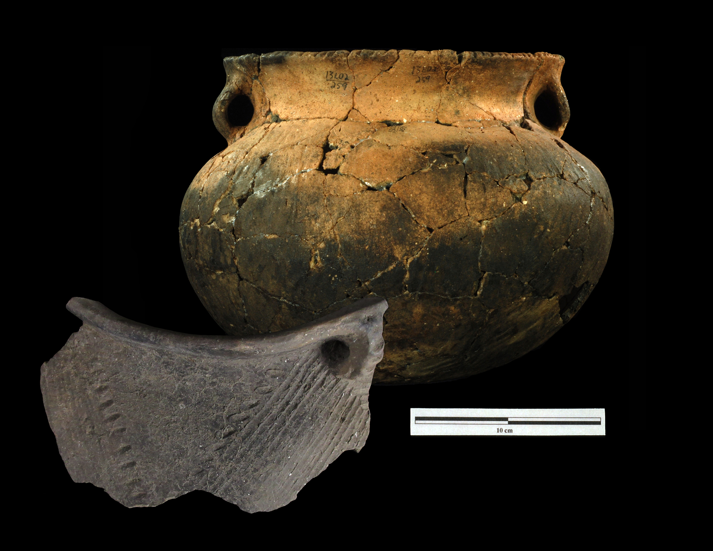
Mill Creek people crafted bone tools (hoes, knives, fishhooks, awls) and ornaments (beads, pendants, bone pins), showing both artistry and spiritual expression. Pottery was varied and decorated with geometric designs, sometimes shaped as animals or birds [14]. Trade reached as far as Cahokia, evidenced by shared materials like shell-tempered pottery and marine shell beads [15][16][17]. Many villages were protected by ditches or stockades, hinting at conflict, which may have contributed to their eventual disappearance [18][19].
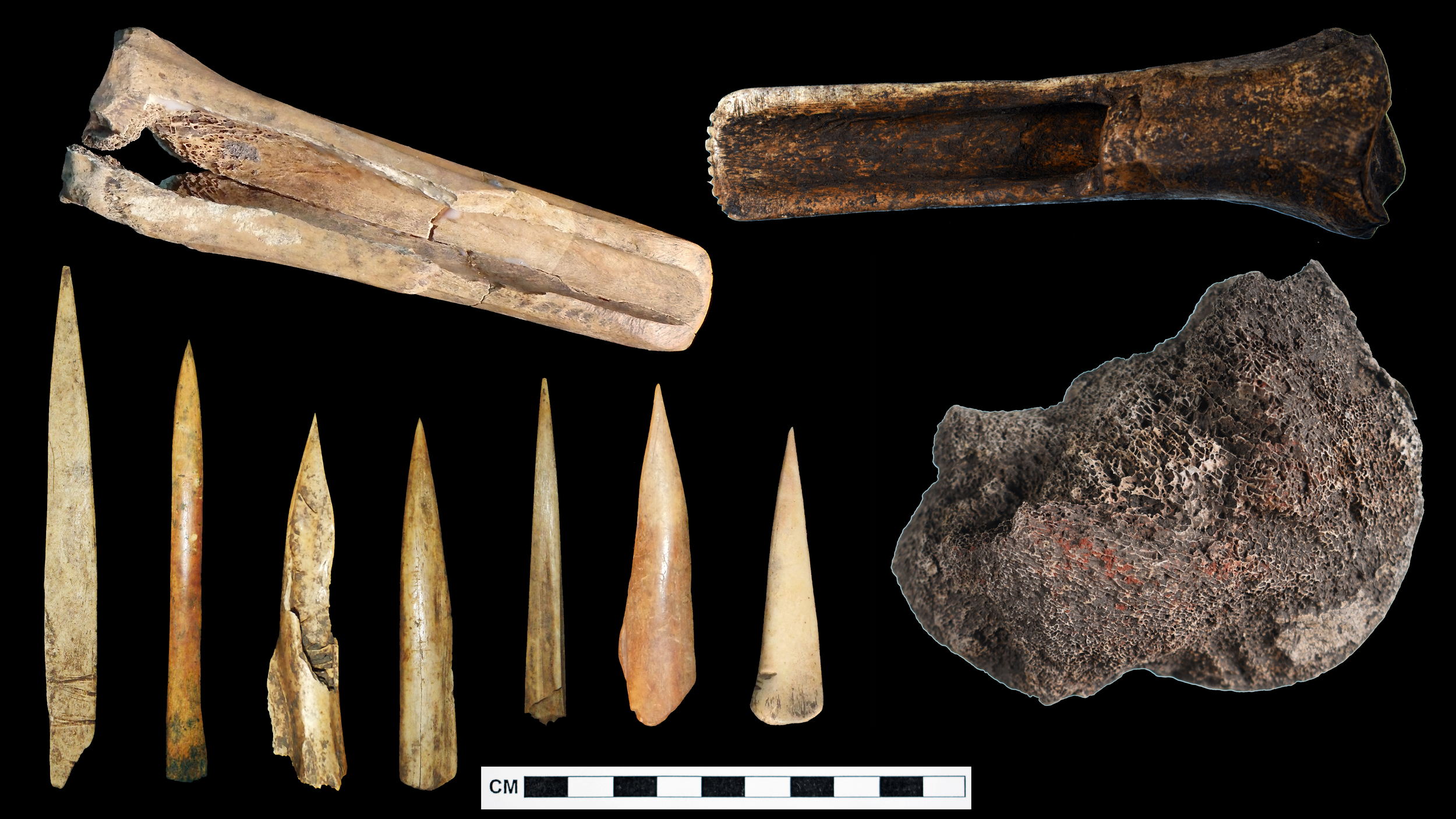
Bone tools were used extensively by the Mill Creek Culture peoples.
(Image: University of Iowa Office of the State Archaeologist)
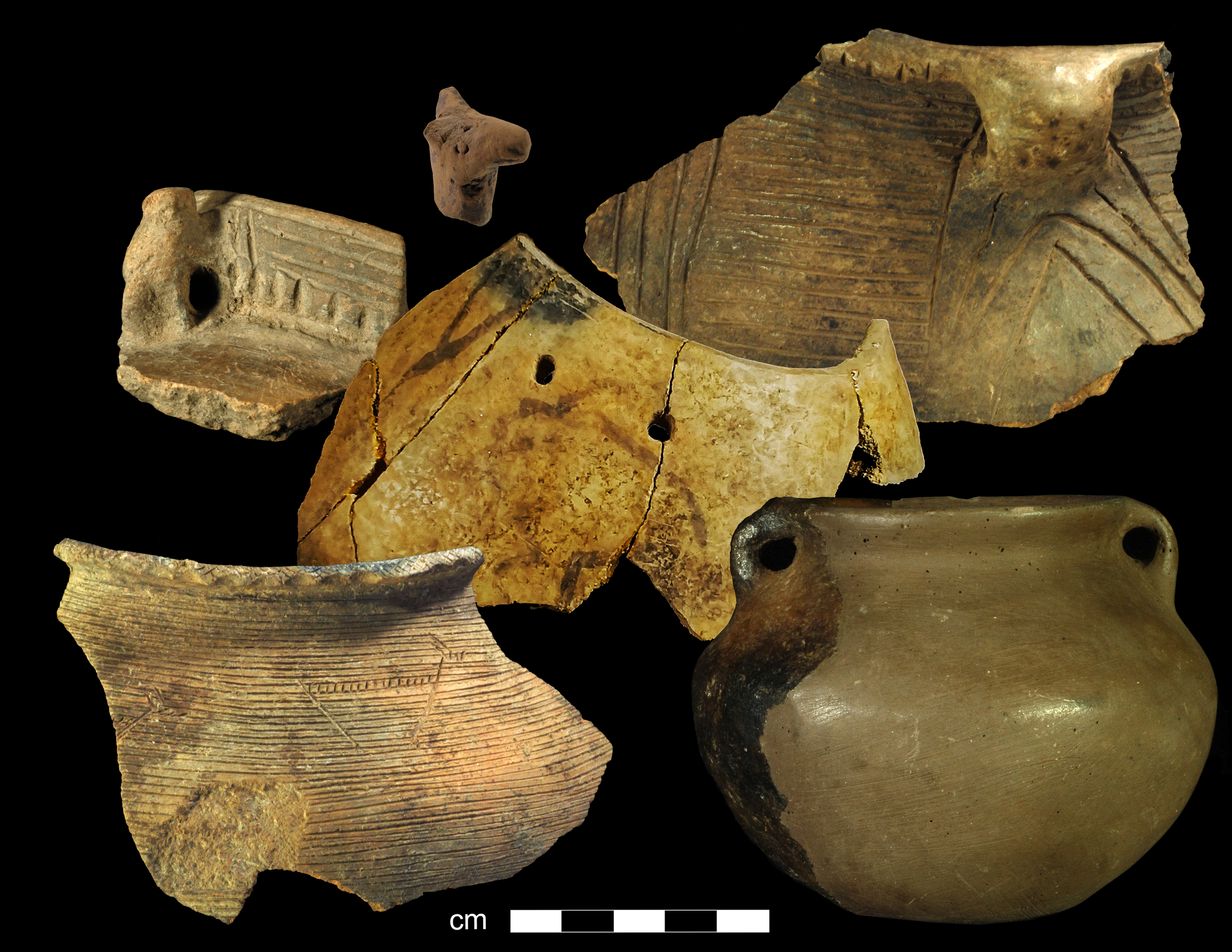
Mill Creek Pottery was varied and decorated with geometric designs, sometimes shaped as animals or birds. Trade reached as far as Cahokia (St. Louis), evidenced by shared materials like shell-tempered pottery and marine shell beads.
(Image: University of Iowa Office of the State Archaeologist)
Oneota Culture (CE 1200–1700)
The Oneota people likely migrated from Wisconsin, expanding into Iowa and neighboring Plains regions [20]. Their large, sometimes 100-acre villages were farming hubs along river floodplains. Houses were long and rectangular, with central hearths and deep storage pits. They cultivated corn, beans, squash, and tobacco, supplemented by hunting, fishing, and gathering [21].
Oneota ceramics were distinctive—globular vessels with shell temper, strap handles, and incised or trailed decorations. They also carved pipestone (Catlinite) into ceremonial pipes and tablets, many of which remain sacred to descendant communities.
The Late Precontact Period in northwest Iowa was marked by intensive agriculture, permanent settlements, artistic craftsmanship, extensive trade, and complex social life, laying the cultural groundwork for the Native nations that followed [22][23].
A map of Oneota sites in Northwest Iowa.
(Map: University of Iowa Office of the State Archaeologist)
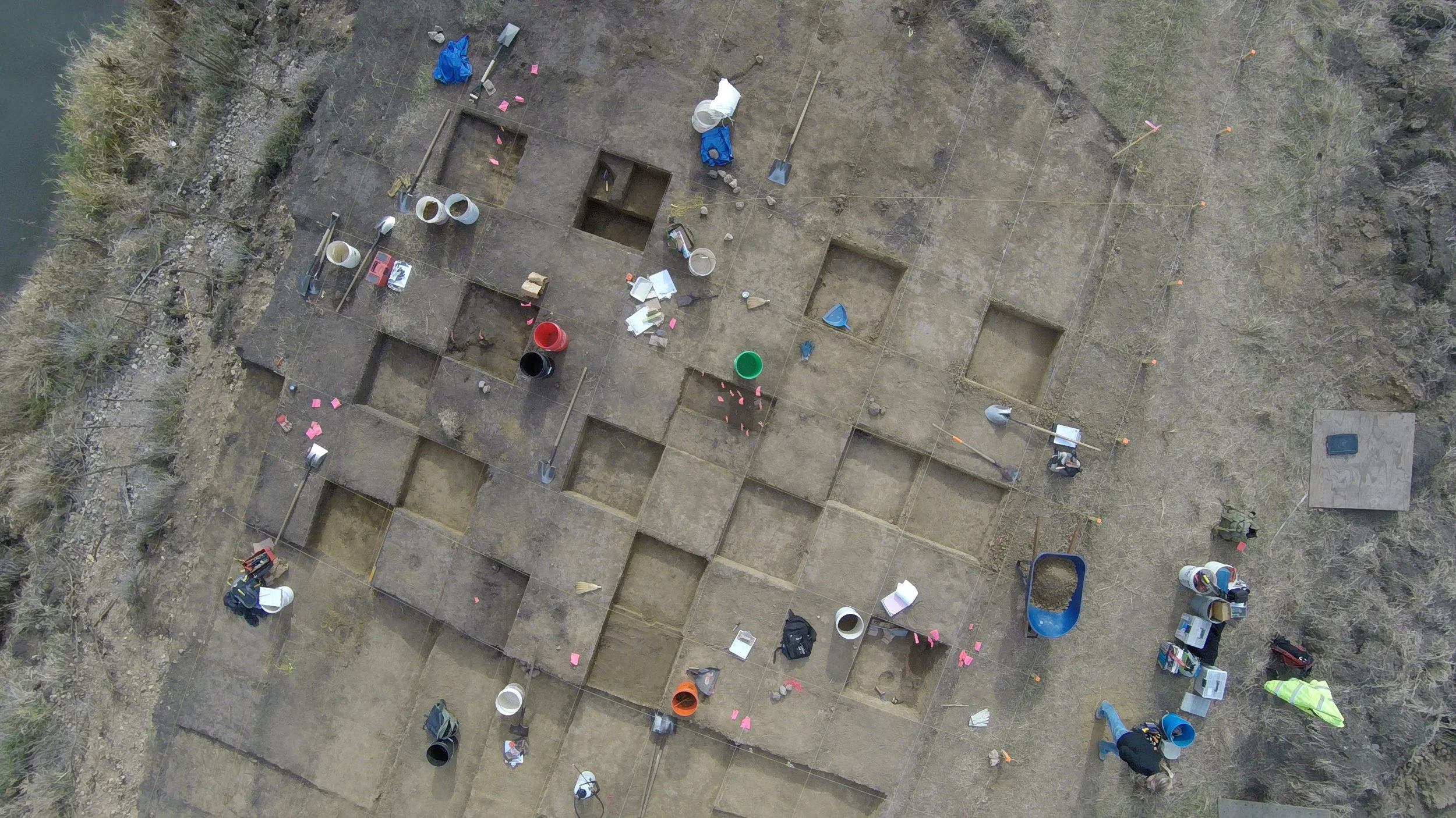
The Dixon site (13WD8) in Woodbury County as seen from above. It was a large and extensively studied thirteenth-century Oneota village on the banks of the Little Sioux River in Woodbury County that has well-preserved features, artifacts, and plant and animal remains.
(Image: University of Iowa Office of the State Archaeologist)
Oneota Ceramics were distinctive—globular vessels with shell temper, strap handles, and incised or trailed decorations.
(Image: University of Iowa Office of the State Archaeologist)
Red pipestone or Catlinite is a type of claystone or metamorphosed mudstone. This soft stone was worked into pipes and small plaques or tablets that were likely used in religious or ceremonial occasions. Because these pipes and tablets are still considered sacred objects, museums are shifting to displaying of replicas and illustrations, and many items are being repatriated.
(Image: University of Iowa Office of the State Archaeologist)
First Contact
When Europeans first entered northwest Iowa, the region was home to many Indigenous Nations with diverse languages, societies, and trade networks. Archaeological and oral evidence links the Oneota culture to the ancestors of the Ho-Chunk (Winnebago), Iowa, Missouria, Omaha, Otoe, Ponca and Dakota [24][25].
One of the largest Indigenous centers was Blood Run, a vast settlement on the Big Sioux River (ca. 1500–1700 CE) that served as a major trade and cultural hub for groups including the Omaha, Ponca, Otoe, Iowa, Arikara, Dakota, and Cheyenne [26].
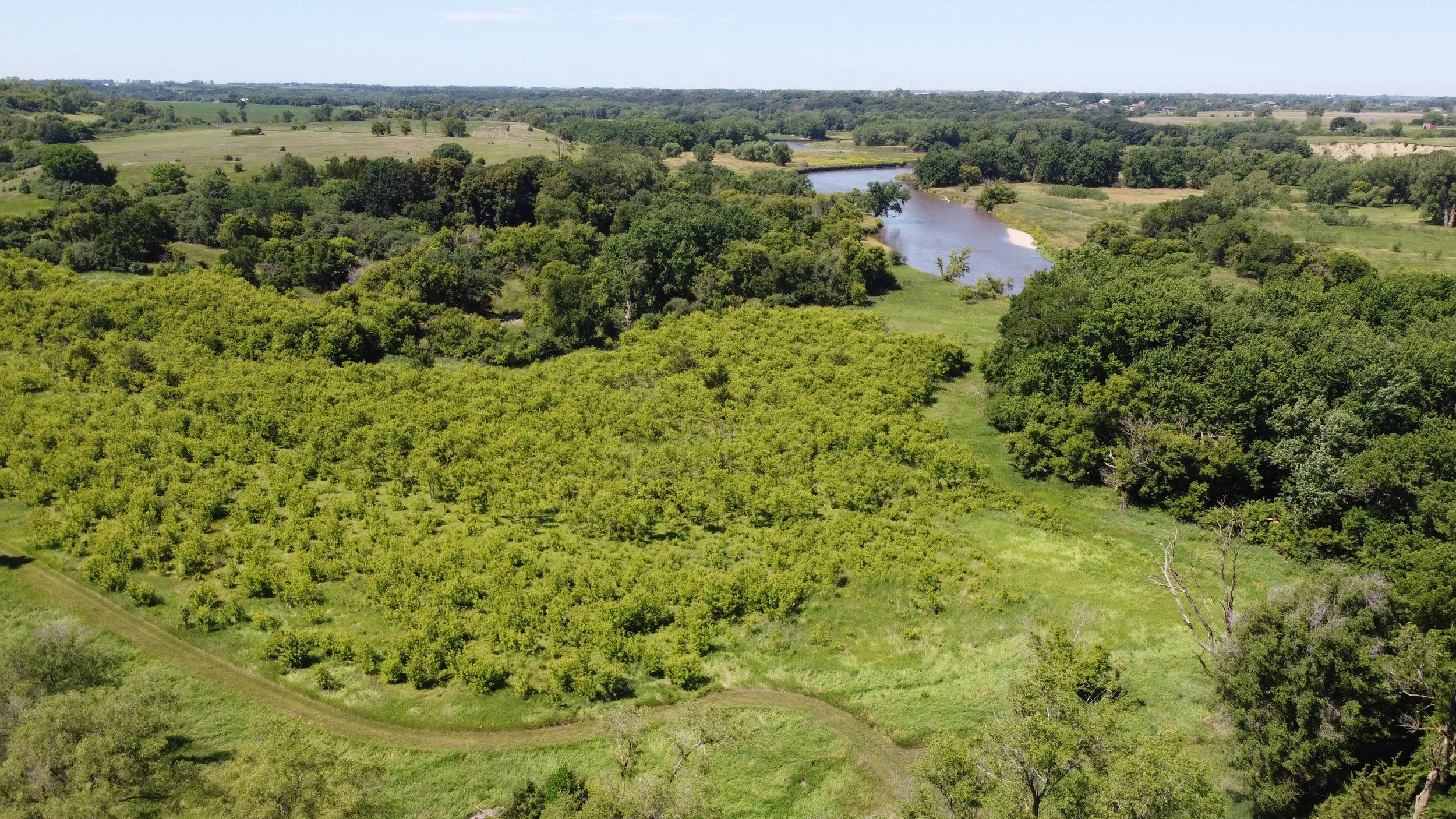
The Big Sioux river valley as seen today near Blood Run National Historic Site.
(Image: Jordan Barry)
French Exploration and Trade
By the early 1700s, French explorers and fur traders (voyageurs) mapped the region and used long-established Native trails for travel and commerce. The 1702 Delisle Map and the 1718 Chemin des Voyageurs (“Path of the Voyageurs”) recorded routes linking the Mississippi to the Missouri River.
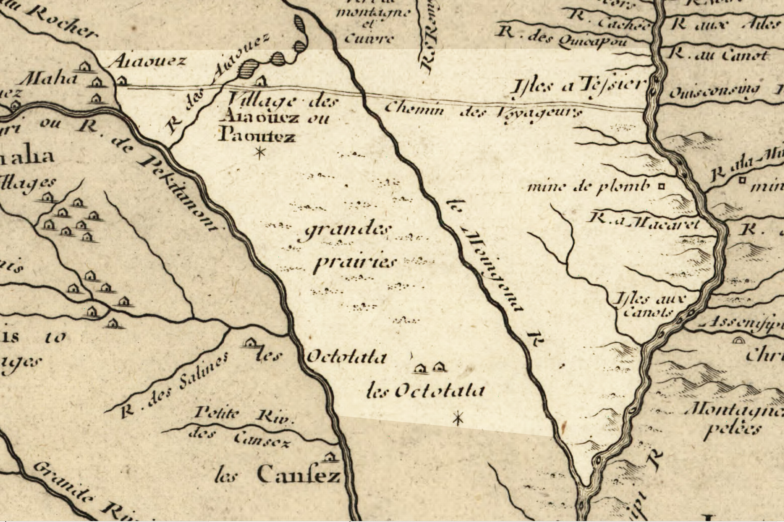
1718 French map showing the route of the Chemin des Voyageurs (Tail of the Voyageurs), the locations of a number of Native American villages and other features.
(Map: Library of Congress Geography and Map Division Washington, DC)
U.S. Expansion
Following the Louisiana Purchase (1803), the Lewis and Clark Expedition (1804) explored the Missouri River region, recording the land’s natural resources and establishing contact with Native Nations. During this journey, Sergeant Charles Floyd died near present-day Sioux City—the only death on the expedition.
No Heart Map (1837)
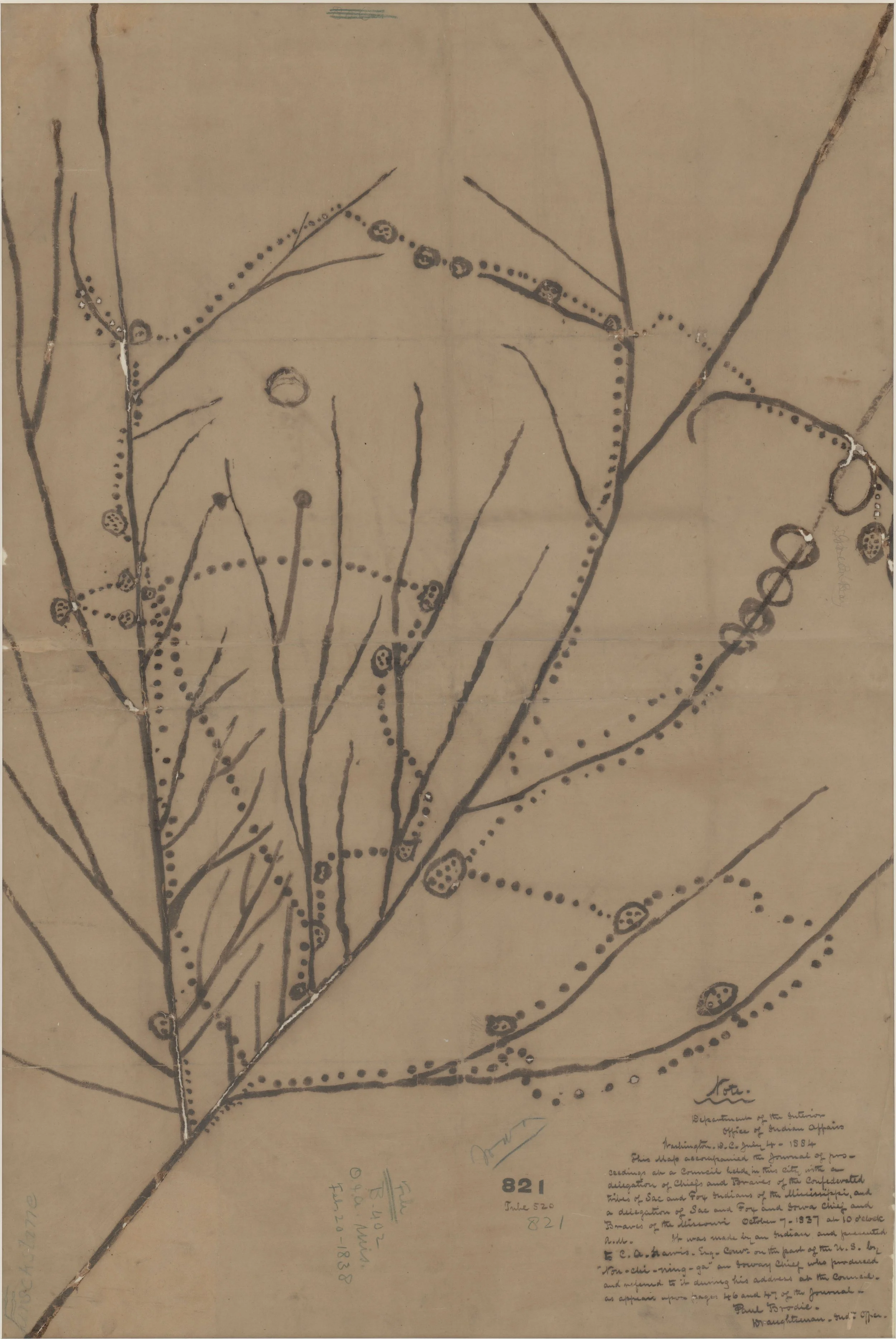
In 1837, a delegation of Báxoǰe (Iowa) elders, led by Nahje Niŋe (No Heart of Fear), traveled to Washington D.C. to present a map of their ancestral homelands to government officials. This map is remarkable because it is the only non-European or non-American map made of Iowa in the 1800s, and it represents the history of the Báxoǰe from the time of their creation to 1837. This invaluable historical document resides at the National Archives in Washington D.C.
(Map: US National Archives and Records Administration)
Euro-American Settlement
After 1833, the U.S. opened lands west of the Mississippi to settlers. Though difficult terrain slowed migration, pioneers gradually arrived in northwest Iowa. Among the first were Robert and Catherine Perry (1856) and members of the Milford Emigration Company, who founded Cherokee along the Little Sioux River [27]. The town later relocated in 1870 to align with the new Fort Dodge–Sioux City railroad, becoming New Cherokee. Today, the community preserves several historic sites and districts reflecting this early development.
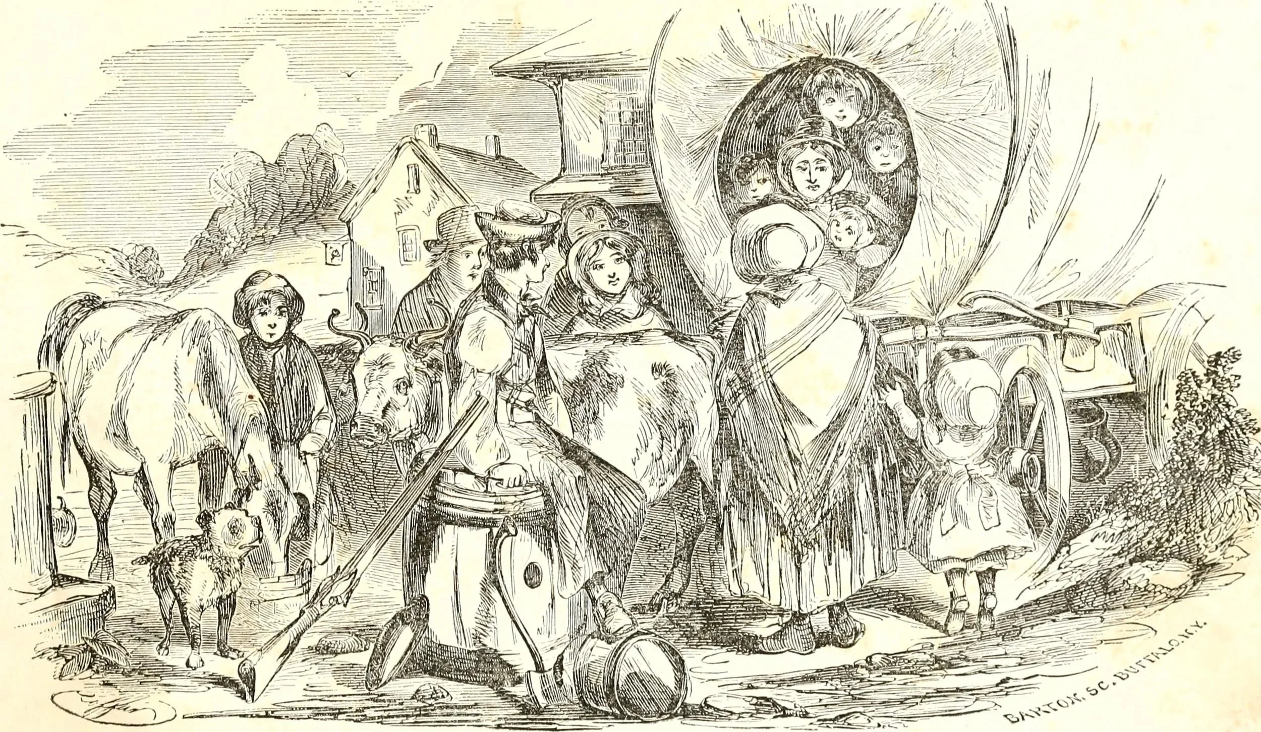
Euroamerican pioneers loaded up their wagons and headed west.
(Image: Internet Archive Book Images, Jacob Ferris 1856)
Settlement Struggles
Early settlers along the Little Sioux River faced extreme challenges including pests, severe weather, and conflicts with Native peoples.
Insects: Mosquitoes were a constant nuisance, but Rocky Mountain locust swarms (1857, 1867, 1873, 1876) were catastrophic, destroying crops, trees, and property. Settlers tried various methods to control them—burning, tar scrapers, smudging—but losses were devastating [28]. Some settlers lost their homes and livelihoods, and the hardest-hit area became known as Poverty Ridge.
Weather: Hot, dry summers caused prairie fires that destroyed homes and supplies (e.g., the 1871 fire in Clay, Emmet, and Palo Alto counties). Winters brought deadly blizzards, with extreme cold, whiteout conditions, and documented fatalities [29].
Cultural Conflict: Westward expansion displaced Native peoples, limiting their access to traditional resources like bison, elk, and deer. Conflicts arose as settlers plowed the prairie and settled the land, affecting tribes such as the Wahpekute band of Dakota [30].
Settlers endured relentless environmental and social hardships, from locust plagues and deadly weather to tensions with Indigenous peoples, shaping the difficult early history of the region.
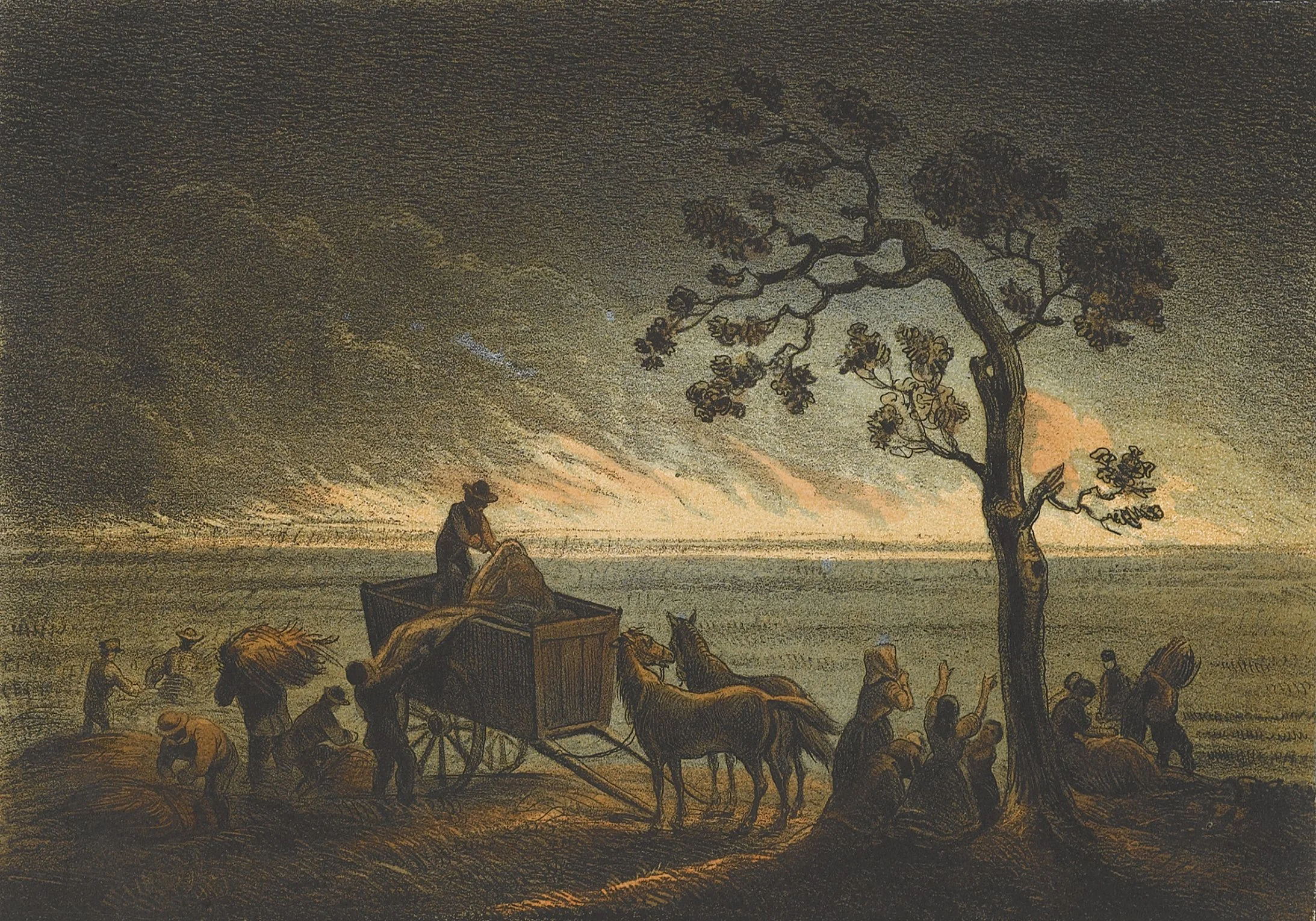
An illustration of a prairie fire on the plains.
(Image: Prairie on Fire, Henry Lewis ca. 1854-8)
Settlement to Present
Frontier Forts: In response to conflicts with Native peoples (1856–57, 1862), settlers and the Iowa state government built forts and organized home guards for protection [31]. Triangular forts were established at Cherokee, Correctionville, and Peterson, but poor designs and the lack of further attacks led to their abandonment and dismantling by 1864.
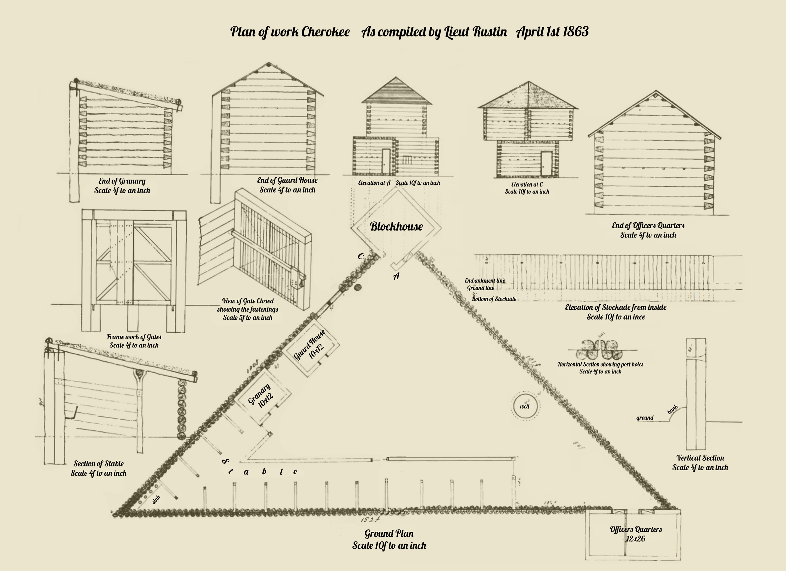
Cherokee fort plan by Lieutenant James Rustin, April 1863, showing the exact details and measurements of all structures. The labels have been modified for clarity.
(Credit: University of Iowa Office of the State Archaeologist, adapted from McCusick 1975)
Railroads and Settlement: Post-Civil War railroads (McGregor & Western, Sioux City & St. Paul) accelerated settlement in northwest Iowa, connecting farms to markets. Towns like Spirit Lake and Spencer thrived, with ice harvesting, tourism, hotels, and cultural venues like the Grand Opera House (destroyed by fire in 1931) [32].
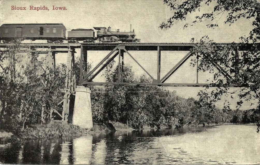
Postcard of the Minneapolis & St. Louis Railroad Bridge over the Little Sioux River near Sioux Rapids, postmarked 1913.
(Image: photolibrarian, flickr)
Civilian Conservation Corps: During the Great Depression, the CCC developed Iowa’s state parks, building infrastructure like roads, bridges, shelters, and labs (e.g., Lakeside Laboratory in Milford), leaving a lasting impact on regional recreation and conservation [33].
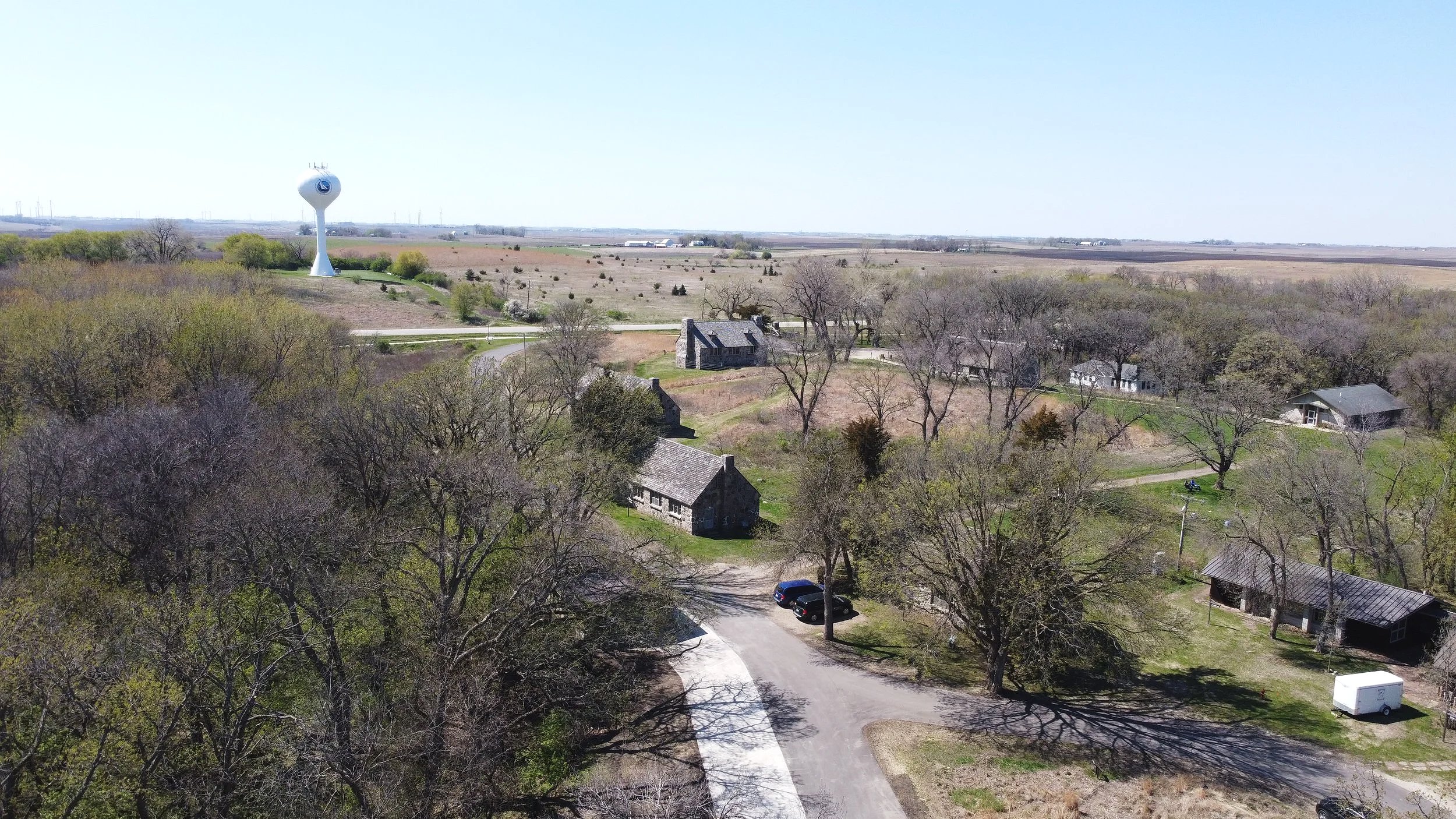
Lakeside Laboratory’s Stone Laboratories were built in the 1930’s by a regional CCC unit.
(Image: Jordan Barry)
World Wars: Northwest Iowans contributed both militarily and on the home front, increasing agricultural production, rationing food and fuel, and supporting war industries. Hemp production and POW labor (Algona/Storm Lake) aided the war effort. Post-WWII humanitarian efforts included the 1947 Friendship Train, with Iowa communities sending food and supplies to Europe [34].

A poster produced by the United States Food Administration during World War Two
(Image: Library of Congress)
Conservation & Public Land
Iowa’s limited public lands—just 2.8% of the state—make the Little Sioux River a powerful lens for understanding the history and importance of conservation in the state. The early 1900s marked Iowa’s first coordinated efforts to preserve natural areas through the Iowa Conservation Commission (ICC), whose leaders identified and protected significant landscapes and helped launch a major era of park creation. Early Iowa Conservationists include, Bohumil Shimek, Thomas MacBride, Louis Pammel and Ada Hayden.
New Deal programs later expanded and improved parks across the state, including those along the Little Sioux. After World War II, responsibility gradually shifted toward local governments, leading to today’s diverse network of state parks, preserves, and county conservation areas. Despite ranking near the bottom nationally for public land acreage, Iowa’s past and ongoing efforts highlight the importance of stewarding the valuable natural and cultural resources that remain.

Dr. Ada Hayden
(Image: Iowa State University Library Digital Collections)

‘The Inkpaduta Canoe Trail Opening’
(Newspaper Excerpt: Sioux City Journal, June 18th, 1989)
References & Acknowledgements
Morrow, Toby A. 1984. Iowa Projectile Points. Special Publication. University of Iowa Office of the State Archaeologist, Iowa City.
Morrow, Toby A. 1984. Iowa Projectile Points. Special Publication. University of Iowa Office of the State Archaeologist, Iowa City.
Hoyer, Bernard. 1980. The Geology of the Cherokee Sewer Site. In The Cherokee Excavations: Holocene Ecology and Human Adaptations in Northwestern Iowa, edited by Duane C. Anderson and Holmes A. Semken, Jr., pp. 21-66. Academic Press, New York.
Alex, Lynn M. 2000. Iowa’s Archaeological Past. University of Iowa Press, Iowa City.
Henning, Dale R. (editor). 1974. The Cherokee Sewer Site (13CK405): A Preliminary Report of a Stratified Paleo-Indian/Archaic Site in Northwestern Iowa. Journal of the Iowa Archeological Society 21:1–175.
Alex, Lynn M. 2000. Iowa’s Archaeological Past. University of Iowa Press, Iowa City.
Benn, David W. (editor). 1990. Woodland Cultures on the Western Prairies: The Rainbow Site Investigations. Report 18. University of Iowa Office of the State Archaeologist, Iowa City.
Benn, David W. (editor). 1990. Woodland Cultures on the Western Prairies: The Rainbow Site Investigations. Report 18. University of Iowa Office of the State Archaeologist, Iowa City.
Asch, David and William Green. 1992. Crops of Ancient Iowa: Native Plant Use and Farming Systems. Submitted to Leopold Center for Sustainable Agriculture, Leopold Center Grant Number 90-34. Report on file at the University of Iowa Office of the State Archaeologist, Iowa City.
Benn, David W. (editor). 1990. Woodland Cultures on the Western Prairies: The Rainbow Site Investigations. Report 18. University of Iowa Office of the State Archaeologist, Iowa City.
Alex, Lynn M. 2000. Iowa’s Archaeological Past. University of Iowa Press, Iowa City.
Alex, Lynn M. 2000. Iowa’s Archaeological Past. University of Iowa Press, Iowa City.
Kendall, Bryan S. 2014. Phase IA Cultural Resources Reconnaissance of the Little Sioux River Water Trail Corridor through Buena Vista, Cherokee, Clay, Dickinson, Ida, O’Brien and Woodbury Counties, Iowa. Submitted to Iowa Department of Natural Resources, Contract Completion Report 2070. Report on file at the University of Iowa Office of the State Archaeologist, Iowa City.
Alex, Lynn M. 1976. Mill Creek. Newsletter of the Iowa Archeological Society 82:11–14.
Alex, Lynn M. 1976. Mill Creek. Newsletter of the Iowa Archeological Society 82:11–14.
Richard L. 1995a. Excavations at the Phipps Site (13CK21): New Perspectives on Mill Creek Culture. Submitted to Department of the Interior, National Park Service and Office of Historic Preservation, State Historical Society of Iowa, Contract Completion Report 443. Report on file at the University of Iowa Office of the State Archaeologist.
Henning, Dale R. 1967. Mississippian Influences on the Eastern Plains Border: An Evaluation. Plains Anthropologist 12:184-194.
Fishel, Richard L. 1995a. Excavations at the Phipps Site (13CK21): New Perspectives on Mill Creek Culture. Submitted to Department of the Interior, National Park Service and Office of Historic Preservation, State Historical Society of Iowa, Contract Completion Report 443. Report on file at the University of Iowa Office of the State Archaeologist.
Alex, Lynn M. 2002a. Office of the State Archaeologist Educational Series 5: Mill Creek. Electronic document, https://digital.lib.uiowa.edu/node/115230, accessed June 1, 2025.
Fishel, Richard L. 1995b. Excavations at the Dixon Site (13WD8): Correctionville Phase Oneota in Northwest Iowa. Submitted to State Historical Society of Iowa, Contract Completion Report 442. Report on file at the University of Iowa Office of the State Archaeologist.
Alex, Lynn M. 2002b. Office of the State Archaeologist Educational Series 7: Oneota. Electronic document, https://digital.lib.uiowa.edu/node/359187, accessed June 4, 2025.
Fishel, Richard L. (editor). 1999. Bison Hunters of the Western Prairies: Archaeological Investigations at the Dixon Site (13WD8), Woodbury County, Iowa. Report 21. University of Iowa Office of the State Archaeologist, Iowa City.
Anderson, Mark L. and Bryan S. Kendall. 2023. Bank Stabilization Data Recovery for the Dixon Site (13WD8), an Oneota Occupation in Northwest Iowa, Primary Roads Project STPN-031-1(41)--2J-97, Woodbury County, Iowa. Submitted to Location and Environment Bureau, Iowa Department of Transportation, Technical Report 1000. Report on file at the University of Iowa Office of the State Archaeologist, Iowa City.
Schermer, Shirley J., William Green, Larry J. Zimmerman, Linda Forman, and Robin M. Lillie. (editors). 2015. Oneota Historical Connections: Working Together in Iowa. Report 24. University of Iowa Office of the State Archaeologist, Iowa City.
Foster, Lance. 2015. Oneota Affiliations and Archaeological Consultations: A 1997-2014 Retrospective. In Oneota Historical Connections: Working Together in Iowa, edited by Shirley J. Schermer, William Green, Larry J. Zimmerman, Linda Forman, and Robin M. Lillie, pp. 143-150. Report 24. University of Iowa Office of the State Archaeologist, Iowa City.
Henning, Dale R. Oneota and the Chiwere Presence in Northwest Iowa. In Oneota Historical Connections: Working Together in Iowa, edited by Shirley J. Schermer, William Green, Larry J. Zimmerman, Linda Forman, and Robin M. Lillie, pp. 39–44. Report 24. University of Iowa Office of the State Archaeologist, Iowa City.
Pioneer Publishing Company. 1917. History of Emmet County and Dickinson County, Iowa: A Record of Settlement, Organization, Progress and Achievement, Vol. 1. Pioneer, Chicago.
Marks, Constant R. (editor). 1904. Past and Present of Sioux City and Woodbury County, Iowa. S. J. Clarke, Chicago.
Pioneer Publishing Company. 1917. History of Emmet County and Dickinson County, Iowa: A Record of Settlement, Organization, Progress and Achievement, Vol. 1. Pioneer, Chicago.
Mason, Kevin T. 2021. Inkpaduta in Iowa: Dakota Decline, Dispossession, and Erasure. Annals of Iowa 80(2):123-157.
Rogers, Leah D. 2009. Northern Border Brigade Forts, 1857–1863. In Frontier Forts of Iowa: Indians, Traders, and Soldiers, 1682–1862, edited by William E. Whittaker, pp. 193–206. University of Iowa Press, Iowa City.
Hofsommer, Donovan L. 1975. Railroad Promotion of the Iowa Great Lakes Area. Annals of Iowa 42:630–638.
Stoever, David L. 1995. The Iowa Great Lakes Region: An Area Rich in Iowa History. Iowa Conservationist 54(4):26-28.
Thomas, Gerald W. 2023. Food Will Win the War--And Shape the Peace that Follows. Air Group 4 “Casablanca to Tokyo,” https://airgroup4.com/food.htm, accessed May 30, 2025.
This section, “Culture & History,” was originally developed and written by Chérie Haury-Artz under the title, “People and the Land: 13,000 Years of Culture & History Along the River”. Significant contributions were also made by Dr. Kevin Mason under the original title, “Nature’s Commons: Discovering Parks and Preserves That Belong to Us All.” Edits were made by Elizabeth C. Reetz and Chérie Haury-Artz.
This section was adapted for the web by Jordan Barry. The page heading video was captured by Jordan Barry. Additional imagery and maps were provided by The University of Iowa Office of the State Archaeologist.
This section was prepared for Iowa Department of Natural Resources Water Trails Program under coordination by John Wenck.