
Geology
By Pete Moore
The landscape of northwestern Iowa reflects the lasting impact of the Pleistocene Ice Age, when glaciers repeatedly advanced and retreated over the region during the past 2.5 million to 11,700 years. These massive ice sheets left behind thick layers of glacial sediment and shaped the land into a complex mix of ridges, valleys, and plains.
The Little Sioux River flows through terrain molded by three major glacial episodes — the Pre-Illinoian, Middle Wisconsinan, and Late Wisconsinan — arranged from oldest in the south and west to youngest in the north:
Des Moines Lobe (Late Wisconsinan): A geologically young area near the river’s headwaters, with fresh glacial landforms and poorly developed drainage.
Sheldon Creek Surface (Middle Wisconsinan): Slightly older terrain with smoother hills and early stream networks, often blanketed by windblown loess.
Pre-Illinoian Surface: The oldest landscape, deeply eroded by rivers, loess-covered, and stripped of visible glacial features.
As it flows from Minnesota to the Missouri River, the Little Sioux River traces a chronological journey through Iowa’s glacial history, revealing how successive ice ages and subsequent erosion sculpted the state’s modern terrain.
(Video: Jordan Barry)
Before the Ice
Beneath the glacial deposits of northwestern Iowa lies over 1,000 feet of sedimentary rock that preserves the region’s deep geological history. These rocks, mainly Cretaceous-age sandstone and mudstone known as the Dakota Formation, formed about 100 million years ago when the Western Interior Seaway covered much of the Great Plains. Shifting sea levels repeatedly flooded and exposed Iowa, leaving a complex mix of marine and river sediments.
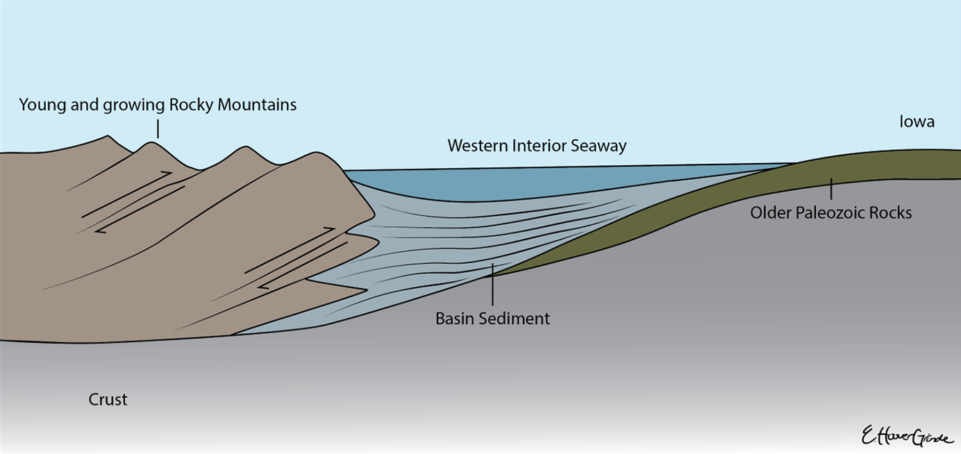
The Western Interior Seaway formed in part due to widespread global sea level rise, but also due to the subsidence of the crust under the growing Rocky Mountains to the west. Many of the rocks found today in the Great Plains are Cretaceous and younger sedimentary rocks formed in this so-called “foreland basin.” The Dakota Formation rocks of western Iowa formed along the eastern edge of this basin.
(Illustration: Emma Hoover Grinde)
During the Pleistocene Ice Age, glaciers buried this ancient landscape under hundreds of feet of till, filling old river valleys with sediment. Although hidden today, these ancient valleys are traced through deep well records. The modern Little Sioux River partly follows two of these buried channels—the Fremont and Anthon valleys—before reaching the Missouri River.
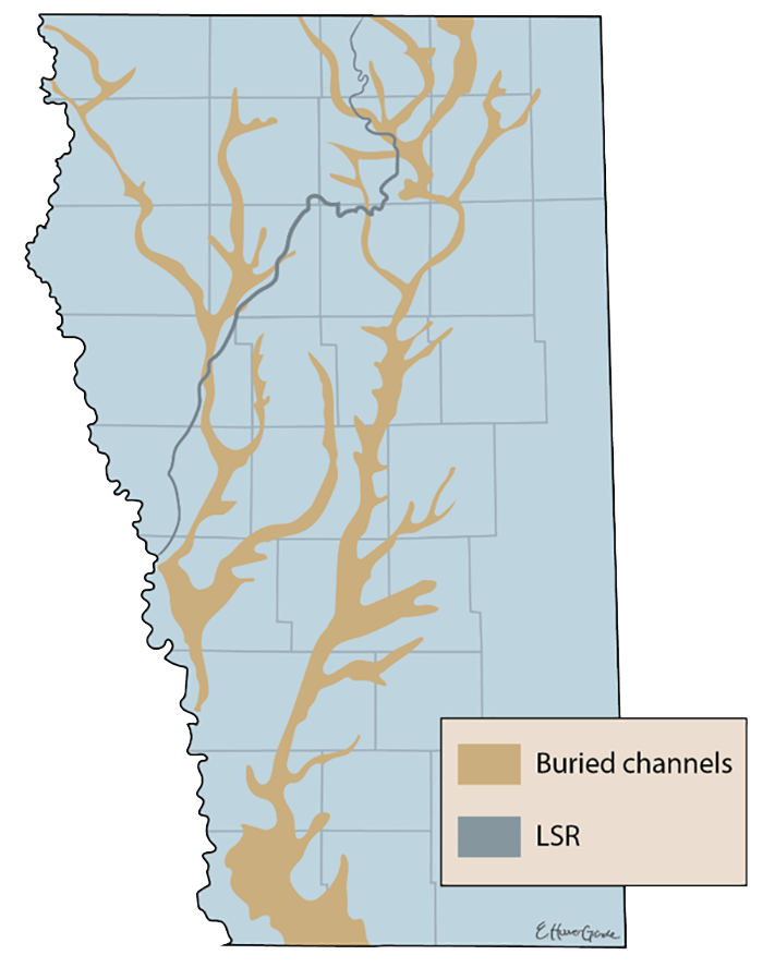
A simplified map of western Iowa showing the modern path of the Little Sioux River (blue) and two major buried channel systems that the Little Sioux passes over (gold).
(Illustration: Emma Hoover Grinde)
Pre-Illinoian Glaciation
The Pre-Illionoian Glaciation brought massive ice sheets, covering Iowa repeatedly—at times reaching as far south as Topeka, Kansas, and St. Louis, Missouri. These glaciers left behind thick layers of glacial till across northwestern Iowa, some hundreds of feet deep. Although the exact number and timing of these early glaciations are uncertain, evidence shows that at least two major Pre-Illinoian ice advances blanketed the entire state, each leaving distinct till layers visible in places like Ranney Knob Recreation Area near Washta.
In areas untouched by later glaciers, such as south of Cherokee, the landscape developed through alternating cycles of erosion and wind deposition during warmer interglacial periods. Streams carved valleys and ridges, while cold, windy conditions during renewed glaciation spread loess (windblown silt) across the land, forming the foundation of Iowa’s modern topography.
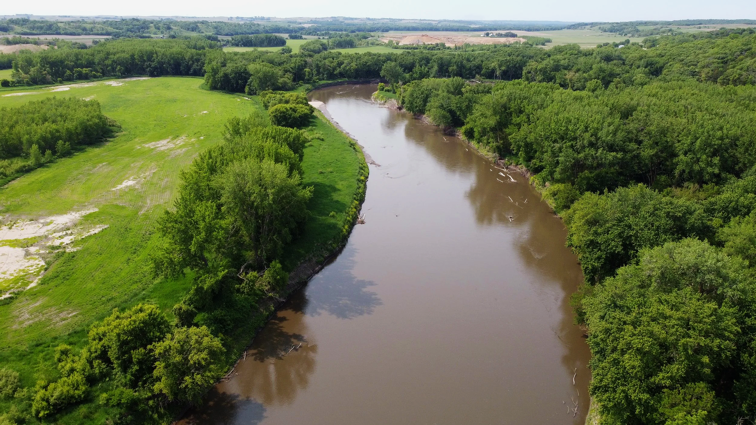
The Little Sioux River near Ranney Knob Recreation Area
(Image: Jordan Barry)
The Wisconsinan Glaciation
The Wisconsinan glaciation marked the last major advance of ice into Iowa. After the earlier Pre-Illinoian events, glaciers did not return to northwest Iowa until the Middle Wisconsinan period about 50,000 years ago, when ice deposited the Sheldon Creek Formation. The resulting Sheldon Creek surface, extending from Milford to Cherokee, features subdued topography, established stream networks, and thin layers of loess (windblown silt).
Later, around 18,000 years ago, the Des Moines Lobe—the most recent glacier—advanced rapidly across Iowa, reaching as far south as modern-day Des Moines. After several re-advances, it finally retreated around 14,000 years ago, leaving behind fresh glacial landforms that erosion has yet to erase.
These glaciers profoundly shaped the landscape by filling ancient river valleys, depositing moraines (ridges marking former ice edges), and creating numerous lakes. Some were short-lived, such as Glacial Lake Spencer, while others left long-lasting marks like ice-walled lake plains and kettleholes—depressions formed as buried ice blocks melted. Features like the Freda Haffner Kettlehole State Preserve exemplify this legacy.
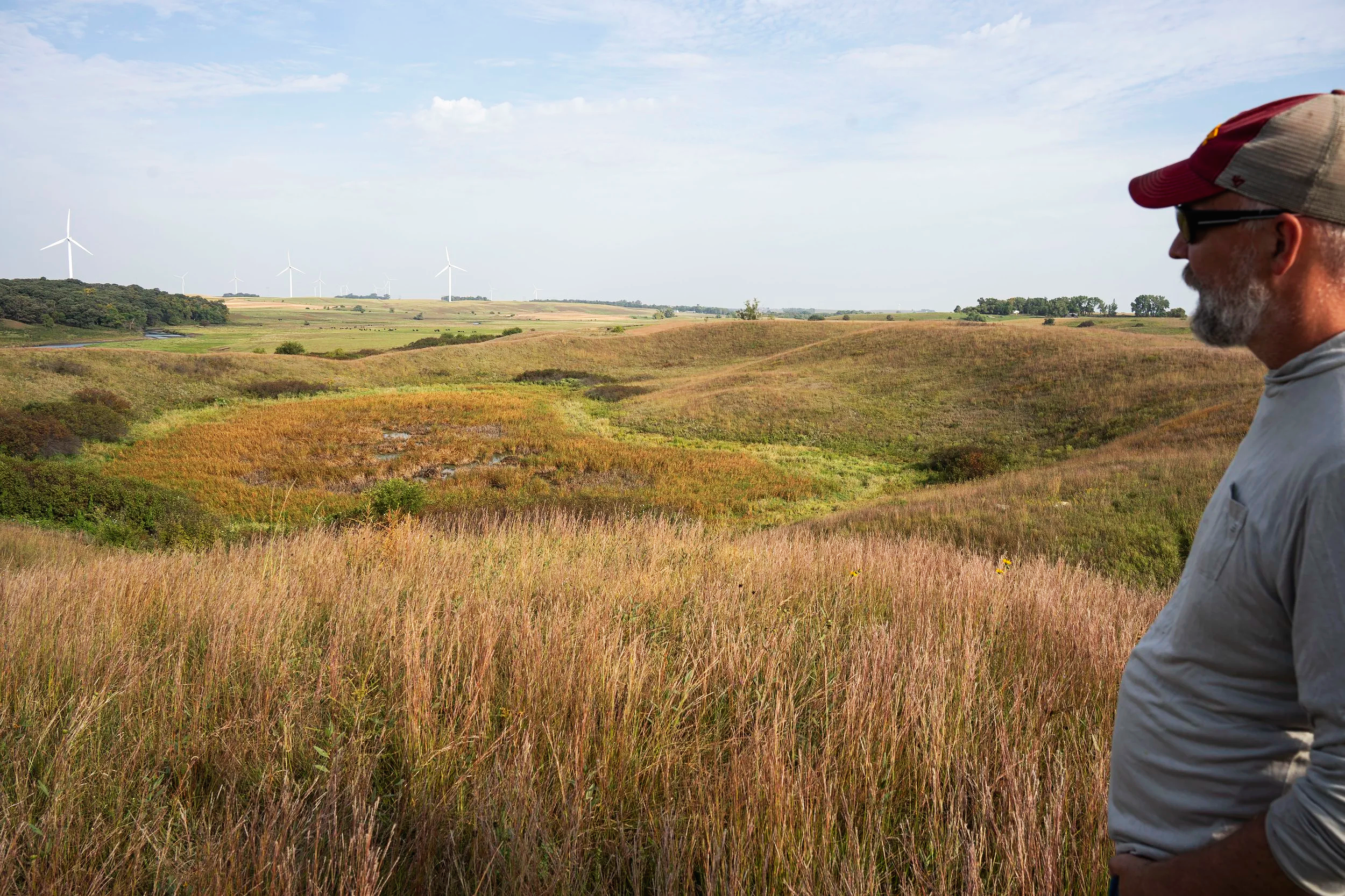
ISU Geology Professor Dr. Pete Moore at the Freda Haffner Kettlehole State Preserve in Dickinson County
(Image: Jordan Barry)
Lasting Impacts of Glaciation
The repeated advances and retreats of glaciers dramatically reshaped the Little Sioux River and its surrounding landscape. Glacial debris built upland features like moraines near Okoboji and Gillett Grove, while advancing ice lobes often blocked river valleys, forcing rivers to carve new paths.
One major event occurred when the Des Moines Lobe advanced around the end of the Pleistocene. The ice blocked the upper Little Sioux River near Gillett Grove, forming a temporary Glacial Lake Spencer. When the lake overflowed, it cut a new channel westward, joining Waterman Creek and permanently establishing the river’s modern course.
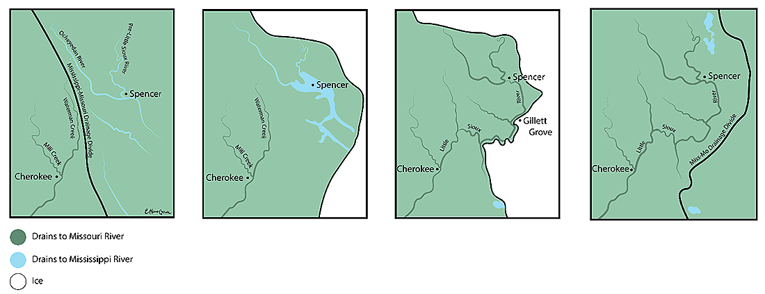
An illustration of how the most recent glacial advance, the Des Moines Lobe, diverted the path of the Little Sioux River towards the Missouri river.
(Illustration: Emma Hoover Grinde)
The valley today preserves this history in a series of river terraces—flat step-like surfaces rising from the floodplain. Each terrace marks an earlier stage when the river flowed at a higher level before cutting deeper into the valley. Up to five distinct terrace levels record this sequence of erosion and river evolution, with the most complete example visible near Quimby in Cherokee County.
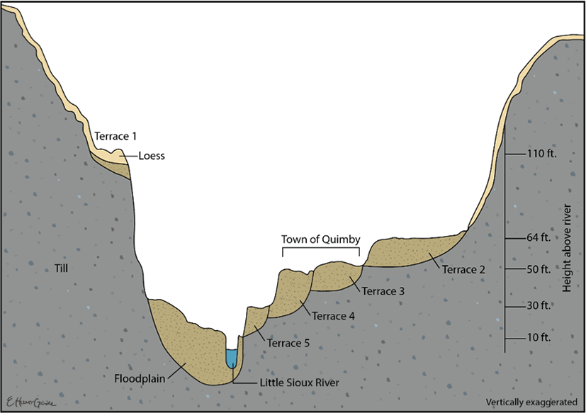
Cross-profile of the Little Sioux River valley near Quimby showing the five different terrace levels recording different stages of carving of the valley since the last pre-Illinoian glaciation.
(Illustration: Emma Hoover Grinde)
Resources from the Ground
The Little Sioux River valley provides vital natural resources, including sand, gravel, and groundwater. Sand and gravel—key ingredients in concrete and asphalt—are heavily mined across Iowa, with the best deposits found in well-sorted river sediments. To reduce environmental impacts, most mining occurs on high river terraces rather than directly beside the river, with visible stockpiles between Sioux Rapids and Correctionville.
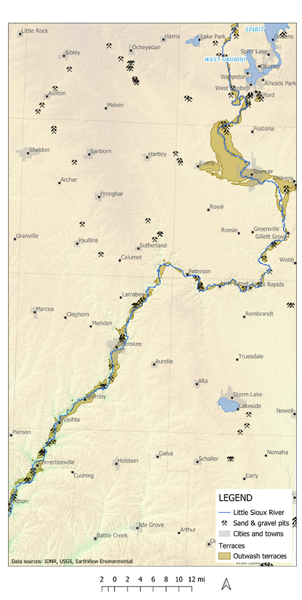
A map indicating the prevalence of sand and gravel pits on or near glacial outwash terraces
(Map: Dr. Pete Moore)
Groundwater in northwest Iowa comes from three main aquifer types:
Bedrock aquifers (like the Dakota Formation) are deep, mineral-rich, and well protected from pollution.
Buried channel aquifers lie between bedrock and glacial deposits, consisting of ancient river sediments shielded by impermeable glacial till.
Alluvial aquifers are shallow, found in modern river valleys, and provide easily accessible but more pollution-prone water for many local towns.
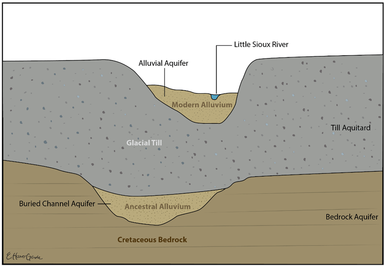
An illustration of the stratigraphy of sediments and bedrock including ancestral alluvium from former river channels
(Illustration: Emma Hoover Grinde)
A Dynamic Modern River
The Little Sioux River is a meandering river that continually reshapes its valley through erosion and sediment deposition, creating dynamic floodplains. Its behavior varies with valley confinement:
Confined valleys limit migration with steep sides.
Semi-confined valleys (common along much of the Little Sioux) allow moderate shifting and create bluffs.
Unconfined valleys (like near Spencer) permit wide meander growth across broad floodplains.
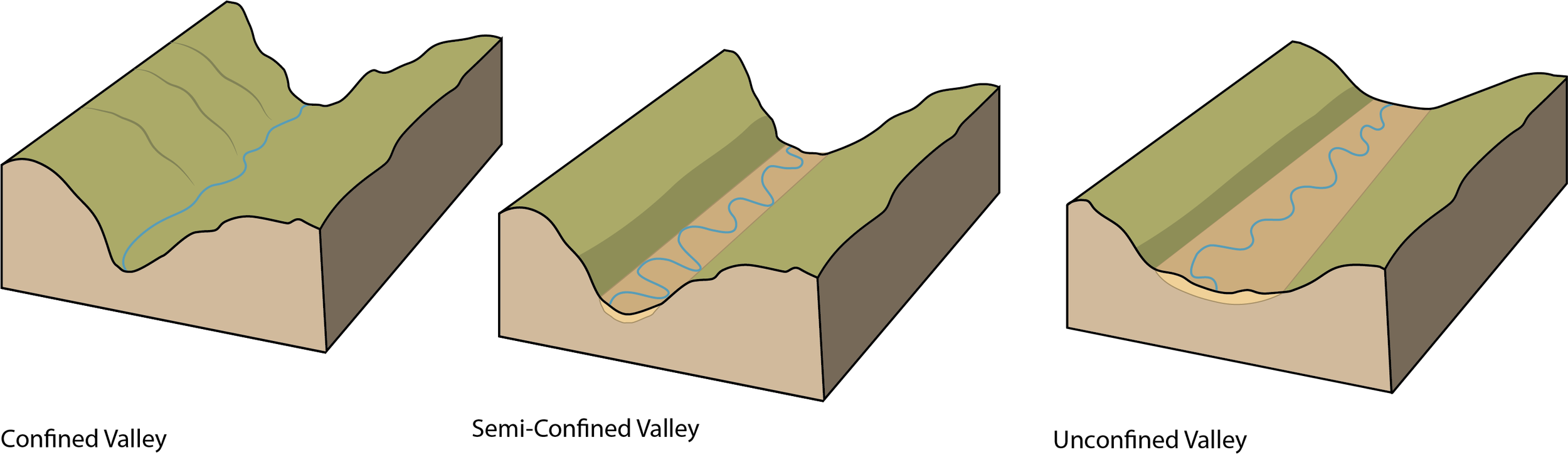
Valley confinement styles exhibited in different sections of the Little Sioux River. Confined valleys are mainly present in small tributaries. Most of the Little Sioux River is semi-confined, except the area around Spencer where it is unconfined.
(Illustration: Emma Hoover Grinde)
As meanders expand, they can form cutoffs, where the river carves a shorter path and leaves behind oxbow lakes. These oxbows—seen near Hawk Valley, Linn Grove, and Wanata Park—provide crucial wildlife habitat, floodwater storage, and water-quality benefits.
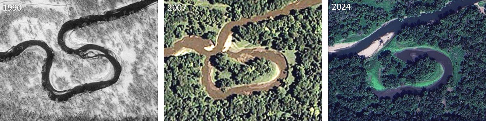
A recently formed oxbow just west of Wanata Park, near Peterson.
(Image: Dr. Pete Moore)
The river’s floods, though often destructive (notably the record 2024 flood), are also ecologically vital, replenishing soils with sediment and nutrients and allowing the river to adjust naturally. However, increasing flood severity linked to climate and land-use changes poses growing challenges. River levels also impact paddling safety, requiring balance between too low and dangerously high flows.
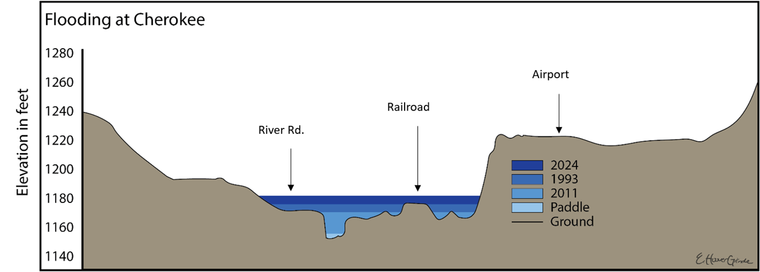
Cross-profile of the Little Sioux River valley on the south side of Cherokee. Blue shading shows different water levels corresponding to historical floods in 1993, 2011, and 2024, along with the water level that is optimal for paddling.
(Illustration: Emma Hoover Grinde)
References & Acknowledgements
This section, “Geology” was originally developed and written by Dr. Pete Moore under the title, “Ice Trails and River Tales: Geology, Glaciers, and the Making of a Landscape”. Edits were made by Elizabeth C. Reetz and Chérie Haury-Artz.
This section was adapted for the web by Jordan Barry. The heading video was captured by Jordan Barry, the graphics were prepared and designed by Emma Hoover-Grinde. Additional imagery was captured by Jordan Barry and Dr. Pete Moore.
This section along with the pages; “Ecosystems, Culture & History, Wildlife and The Dakota in Iowa” were prepared for Iowa Department of Natural Resources Water Trails Program under coordination by John Wenck.